Theoretical Meteorology
Contents
- Introduction
- Air and Water
- Aerostatics
- Lapse Rates
- Lifting Condensation Level
- Charts
- The Wet Bulb
- Stability of an Air Column
- References
Introduction
Meteorology is a branch of applied physics which makes extensive use of a great deal of classical physics, especially thermodynamics and the dynamics of fluids. Descriptive meteorology, or "weather," uses the statics of the atmosphere and the properties of moist air, both of which are more intelligently used when their physical foundations are understood. The purpose of this article is to explain the relationships of pressure, temperature, moisture and altitude in the atmosphere, the use of thermodynamic charts, and the often mysterious world of wet bulb temperatures and dew points. This will be done with as much rigour and with as little handwaving as possible.
The earth's atmosphere is a (relatively) thin sheet of gas firmly attracted to the surface by gravity. The lower 11 km or so is a transition between the surface at around 288K and the upper atmosphere at 218K, in which there is a heat flux from the solar-heated surface to the radiative sink of space, accompanied by active turbulence on all scales that keeps the sheet well-mixed. This layer is the troposphere, which contains most of the water in the atmosphere and all of the weather. Our discussion here mainly concerns this chemically homogeneous, electrically neutral and nonconductive medium, which supports strong electrical fields, and occasionally supports impressive electrical discharges. The regions of atmospheric chemistry and electromagnetism are largely outside the troposphere.
A minor constituent, water vapor, plays a large role in weather. It is not only essential to life, but is part of the water cycle, and is usually evident as clouds or precipitation. The latent heat of water vapor drives convective storms and hurricanes, and is an important heat transfer mechanism. However important, atmospheric water is only a small part of the whole, which resides mainly in the oceans, along with most of the surface heat of the earth and most of the earth's biomass. Our point of view is severely skewed by being land creatures of short existence residing between sky and ground. Solar energy arrives mainly at surface level where the rays are closest to vertical, in tropical regions, and is distributed over the earth by ocean currents. The atmosphere takes its heat from the ground and ocean surfaces, spreads it more or less evenly, and radiates it to space (some radiation goes directly from the surface to space, however) so that the amount radiated is equal to the amount absorbed, on the average. Things happen quickly in the atmosphere, more slowly in the oceans, and on a time scale beyond human appreciation in the earth.
Air and Water
Our tropospheric atmosphere is a mixture of dry air, consisting of 78 parts nitrogen, 21 parts oxygen, and 1 part argon, and some trace gases, by volume, and water vapor. The composition of dry air, insofar as its properties as a gas are concerned, varies insignificantly, so we may consider it of fixed composition. Water vapor, of course, is a pure substance. Dry air and water vapor, for meteorological purposes, behave very closely as ideal gases, and their mixture is also ideal, obeying Dalton's law of partial pressures, which means that the dry air and water vapor occupy the same volume independently, taking no notice of one another. The amount of water vapor is always small, since an excess will readily condense out of the mixture, and run away as liquid water. Seldom is air more than 3% water vapor.
The most important minor constituent is carbon dioxide, required by plants, and so for all living things, for life. It is present in surprisingly small concentrations, about 0.03%, but plants have adapted to the near disappearance of carbon dioxide from our planet's atmosphere. However, its concentration is maintained by processes that are not understood, though argued over enough, so life is safe on this ground. The only meteorological effect of atmospheric carbon dioxide is in atmospheric radiative transfer, where it contributes to the greenhouse effect keeping our planet at a comfortable temperature. The major contributor to the greenhouse effect is water vapor and clouds; carbon dioxide plays only a minor role, together with methane, nitrous oxide, and other trace gases. Climate is probably controlled by the ocean, which is far more massive than the atmosphere, and contains far more carbon dioxide, and makes far more oxygen from photosynthesis than all the green plants on land. The current political debate over carbon dioxide takes place in an atmosphere of rather great ignorance.
Gases of low density, like air and water vapor, obey more or less closely the simple equation of state pv = RT, where p is the pressure, v the volume of the sample under consideration, T the absolute temperature, usually in K, and R is the gas constant. The gas constant may be expressed per gram, in which case v is the volume of 1 gram of the gas, or per mole, where v is the volume of one mole of gas, which contains 6.02 x 10²³ molecules. It is remarkable that the gas constant for one mole of any gas is exactly the same, R* = 8.3144 x 10⁷ erg/K. Note that if p is in dyne/cm2 and v is in cm3, then pv has the dimensions dyne-cm or erg. The most popular unit for energy today is the joule, and 1 J = 107 erg. It is easy to work in J or erg as one sees fit.
The molecular weight M is the weight of one mole in grams. The molecular weight of the mixture that is dry air is 28.97 g, and the molecular weight of water vapor is 18.016. If we want the gas constant per gram, then R = R*/28.97 = 0.2870 J/g-K for dry air, and R' = R*/18.016 = 0.4615 J/g-K. The ratio of R to R', R/R' = 18.016/28.97 = 0.622, usually denoted by ε. This constant is of use when we want the mass of water when we know the ratio of pressures of water vapor and dry air. For example, the mixing ratio x is the grams of water per gram of dry air. If m is the mass of dry air, and m' is the mass of water vapor in the same volume v, then ev = m'R'T and (p - e)v = mRT, where the pressure of water vapor is denoted by e, and the total pressure by p. The ratio of these two expressions is e/(p - e) = (m'/m)(R'/R), or x = m'/m = εe/(p - e). The normal range of x is from 0 to 0.03. The approximate expression x = εe/p is usually close enough. Mixing ratios are usually quoted in grams per kg of air, so they run from 0 to 30, with 10 g/kg being a typical value. Convert them back to g/g for use.
What is the volume of a kilogram of air? If R is the gas constant per gram, then this volume is 1000v = 1000(RT/p). The answer obviously depends on the temperature and the pressure. STP (standard temperature and pressure) is 0°C, and 1 atm, or 1013.25 mb. The millibar (mb) is 1000 dyne/cm2, or 1/1000 of a bar, which is 106 dyne/cm2. 1013.25 mb corresponds to 760 mmHg, where the mercury is at 0°C and standard gravity, 980.621 cm/s2 or gal. Meteorologists agreed to use the millibar, since it is an absolute unit as it stands, and it is not necessary to specify the environment of the mercury used to measure it. The millibar is now often called the hPa, hectopascal, by metric enthusiasts, and this is exactly the same thing. We now know the pressure in dyne/cm2, and the temperature in K is °C + 273.15, so T = 273.15. The volume of a kg of air is then 1000(0.2870 x 10⁷)(273.15)/(1.01325 x 106) = 773.7 cm3. This is less than a cubic metre, and it may come as a surprise that air is this heavy, since it seems so insubstantial. 10 grams of water is a nice little puddle, and it may also be surprising that so much water is commonly present in air, since all of this is quite invisible! It is useful to remember that air at STP weighs 1.2926 kg/m3, and that a mole of any ideal gas at STP occupies 22,400 cm3.
We have already introduced one measure of humidity, the mixing ratio, which is very convenient for doing algebra. The saturation mixing ratio, xs is approximately εes/p, where es is the saturation vapor pressure of water. It is the vapor pressure at equilibrium with liquid water, and will be the equilibrium value whenever liquid water is present. It is not a function of the air pressure, but depends strongly on the temperature. There are tables, but for our purposes it can be calculated with sufficient accuracy from es = 6.11 x 108.573 - 2340/T mb. At 0°C, it is 6.11 mb; at 100°C it is 1013 mb. In weather, it is usually less than about 40 mb.
The relative humidity is f = x/xs = e/es, commonly expressed as a percentage. The absolute humidity is the density of the water vapor, in g/cm3. The gas law gives it as a = e/R'T. The relative humidity is often used as an indicator of the ability of the air to take up more moisture, but the absolute humidity is seldom needed. The most important humidity measure for us is the mixing ratio, which can be grams of water vapor per gram of dry air, or per gram of moist air. In every case, things can be worked out in terms of dry air and water vapor separately, the sum of their pressures being the total pressure, which is measured by the barometer. We shall return later to the important question of finding how much moisture the air contains.
Aerostatics
Gravity is of great importance in meteorology. The sea level acceleration due to gravity is, on the average, g = 980.62(1 - 0.00259 cos 2φ)(1 - z/3185), where z is the elevation in km above sea level, and φ is the latitude. The earth is approximately a sphere of radius 6371 km, and gravity is inversely proportional to the square of the distance from the centre of the earth. The linear decrease with altitude, with coefficient 2/Re, is a sufficiently good approximation for our purposes. Gravity attracts the atmosphere to the earth, and the atmospheric pressure is the weight of air above us. This pressure is quite large, but we do not notice it, having spent all our time at the bottom of the ocean of air. The force on a square foot is more than a ton; the experiment of exhausting the air from a metal can by boiling water in it, and then screwing down the top is famous. The can is crushed by the pressure of the air quite violently. The air is squeezed down on the surface of the earth quite strongly; we do not have to ascend much to notice the decrease in pressure. About 80% of the air is below an altitude of 10 km, so when we fly in a jet, most of the air is below us.
 The aerostatic equation is dp = -ρg dz, which can be found by considering the equilibrium of a thin layer of air of height dz and any area. The difference in pressure forces on the top and bottom is equal to the weight of the air contained. Now, ρ = 1/v = p/RT, so dp/p = d(ln p) = -(g/RT)dz. This equation is of great use to us. g/RT often appears as Mg/R*T, with the universal gas constant. Also, we sometimes define the scale height H = RT/g, so that the aerostatic equation is d(ln p) = -dz/H(z), where H is shown as a function of z, which it often is. Since g decreases with altitude, the combination gdz may be denoted dΦ, where Φ is the geopotential. If a mass m is raised from z = 0 to z = h, its energy is more accurately expressed as mΦ than mgh. A geopotential altitude z' may be defined as Φ/go, using a surface standard value of g. This refinement gives corrections of a few percent, and should not disturb you unless you are making accurate calculations.
If the temperature T is constant, then so is the scale height H. We can allow for the decrease in g with altitude by using the geopotential altitude, if we want. The surface temperature in the standard atmosphere is 15°C or 288K. Then, H = 8.429 km. The aerostatic equation is easily integrated to give ln(p/po) = -z/H, or p = poe-z/H, where po is 1013.25 mb. This does not happen, because the lower atmosphere is by no means isothermal. However, this gives a good idea of the general behavior of a gravitationally attracted atmosphere, and how quickly it becomes rare as one ascends. This equation can be applied practically to the isothermal part of the stratosphere, at a temperature of around -55°C or 218K, where H = 6.38 km, approximately.
More realistically, suppose that T = To - Γz, where Γ is the lapse rate. A constant lapse rate is only a little less rare than isothermal conditions, but it is a much better model for what actually occurs. In this case, dT = -Γdz, and we can write the aerostatic equation as d(ln p) = (g/RΓ) d(ln T). Now if Γ is constant, this can also be integrated easily to find p as a function of T: ln(p/po) = (g/RΓ) ln(T/To). In terms of z, ln(p/po) = (g/RΓ) ln[(To - Γz)/To], or p = po[T/To]g/RΓ. This also gives a rapid decrease in pressure with altitude, but it is not as obvious.
Note that the natural logarithm, to the base e, appears in these equations, which I have emphasized by writing ln instead of log. Only the natural logarithm has the property that d(ln p) = dp/p, which we use frequently. The natural and common logarithms are proportional, log x = 0.4343 ln x, so it is easy to convert from one to the other.
It is of great use in meteorology to know the pressure, temperature and humidity as a function of altitude above a station. For many years, this information had been obtained by aircraft flights, but in 1940 radiosondes, balloon-borne automatic weather stations, completely replaced such flights. The first radio transmitter lifted to the stratosphere by a free balloon was constructed by P. Idrac and R. Bureau in 1927. The history of the radiosonde is of more interest to the science of telemetry than to meterorology, but the radiosonde has been of great value. A few notes on the radiosonde will be given here, but recent transistorized instruments will not be described. For more information, see the References. Radiosondes contain a meteorological sensor package to measure pressure, temperature and humidity, a radio transmitter, an antenna, and batteries. The radiosonde is lifted by a free balloon filled by hydrogen (except in the United States, which wastes scarce helium in this way), and when the balloon bursts at about 15 km, is brought to earth by a parachute. Since the information is telemetered by radio, it can be used in a timely fashion. Earlier balloon meteorographs only recorded internally, and had to be recovered to access the data. The delay of days, months and years rendered them largely useless.
The meteorological instruments were mechanically-registering at first, moving contacts as required. A rotating contact gave the readings as time delays in the time-interval radiosonde. Code radiosondes returned the readings as Morse code, either generated or recorded in the radiosonde. The best and latest form of code radiosonde used a disk like a record with 200 circular grooves, each containing a recorded message. The instruments put the stylus in the proper groove when a reading was to be transmitted. The frequency-modulated radiosonde contained five capacitors, two fixed as references and three variable, one plate moved mechanically, to transmit pressure, temperature and humidity. These capacitors directly controlled the frequency of the transmitter, and were connected in sequence. The fourth type of radiosonde used an audio signal produced by a blocking oscillator controlled by a resistance in its grid circuit. Various resistors could be connected, as the capacitors were in the FM radiosonde, to vary the audio repetition rate of the blocking oscillator. This was the type of radiosonde developed by Diamond, Hinman, Dunmore and Lapham in 1937-40, which became the standard United States type.
The whole instrument weighed only 700g, much of which was the heavy battery for the vacuum-tube transmitter and modulator. At its core was the barometric switch, an aneroid bellows barometer driving a contact arm over a commutator segment of alternate conducting and insulating strips as the pressure changed. The pressure was determined by counting the number of segments passed over. The commutator operated a relay that connected the thermistor element when on an insulating segment, and the humidity element when on a conducting segment. The humidity element consisted of LiCl films whose resistance changed with the relative humidity. The sensor and standard resistances controlled the frequency of the blocking oscillator, which transmitted pulses of RF interrupted at the audio rate. In this way, a continuous record of temperature, pressure and humidity could be obtained as the radiosonde ascended. The original frequency used was 72.2 MHz, but later 1.680 GHz was used, which made direction finding much easier since high-gain dish antennas could be used at the ground base. Another design changed the frequency of the RF oscillator instead, and these radiosondes were used on 403 MHz. With integrated circuits, modern radiosondes can be made much lighter, and the telemetry can be much better. It is now possible for a radiosonde to return its accurate altitude, but this is relatively expensive. We'll assume that we have the report from a traditional radiosonde, and show how to determine the altitude from this information. This used to be done for every radiosonde flight.
Incidentally, upper winds, also important weather information, were determined by rawinsondes, originally balloons carrying transmitters that were tracked by radio direction finders, instead of pilot balloons tracked visually with a theodolite. The 1.680 GHZ frequency made this much easier. Later, radar was used for this purpose.
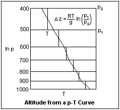 First, we need to introduce the virtual temperature Tv. This is a temperature to use instead of the actual temperature in the ideal gas law for moist air, so that we have pv = RTv. By writing the gas law for dry air and water vapor and adding the pressures, it is not hard to show that Tv = T/[1 - (1 - ε)e/p]. The virtual temperatures must be used in accurate work, but in our examples we will use the ordinary temperature, as if the humidity were very low in our ascent. Then, d(ln p) = -dφ/RTv, where we have used the geopotential Φ, another refinement that we will actually neglect. Now we have ΔΦ = (RTv) Δ(ln p), which we apply to successive layers of the atmosphere. The first step, then, is to plot the p-T results of the ascent on a plot with vertical axis ln p and horizontal axis T. The layers are marked off, and for each layer an average Tv is estimated by eye. For good results, the layers should be no thicker than 100 mb. Then ΔΦ (or gΔz, more simply) can be found for each layer. Then, p and T can be plotted as functions of z.
Suppose the temperatures from 200 mb to 1000 mb, at intervals of 100 mb, were measured at 217K, 230K, 240K, 252K, 260K, 269K, 276K, 283K and 288K. Plot these temperatures against ln p, draw the limits of the layers, and calculate Δz for each one, estimating an average T that will make the intgral correct for each layer. Finally, plot p as a function of z. My results gave 11,703 m for the 200 mb level, 867 m for the 900 mb level, for example.
With accurate direct measurement of the radiosonde height by radar or directional measurements, is is more accurate to dispense with the barometric switch, always a weak link because of its mechanical operation, and determine the pressure using the aerostatic equation by inverting the above process.
Lapse Rates
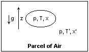 magine a parcel of air that is separated from its surroundings only by an imaginary surface. The reason that we can follow this parcel as it moves is the scale of our problem. We suppose the parcel is convex, shaped like a balloon or pillow, so that its surface area is small compared to its volume. This means that heat and material will exchanged only slowly with the surroundings, although the pressure will quickly equilibrate. Even in the presence of turbulence, the parcel may retain its identity for a considerable time. We shall treat the parcel as a thermodynamic system that we can describe in terms of p, T and x, distinct from its surroundings which are at perhaps a somewhat different temperature T'. At different times, we may consider different parcels of air.
We now need to use some thermodynamics, and a reader not familiar with the subject may find some help in Thermodynamics. Here you will find the TdS equations, as well as a derivation of Clapeyron's equation and a discussion of phase changes--in fact, all you need for meteorological purposes. The second TdS equation states that TdS = CpdT - T(∂V/∂T)pdp in any reversible process where the temperature and pressure change by small amounts. TdS is the heat added to the system in a reversible process, and S is the entropy of the system. Only entropy changes are involved, not the absolute value of the entropy. For an ideal gas, the partial derivative is R*/p, so TdS = CpdT - R*Td(ln p). Cp is the molar heat capacity at constant pressure. The heat capacity per gram is found by dividing by the molecular weight, 28.97. For air, cp = 0.239 cal/g-K = 1.000 J/g-K. For water, cp' = 0.465 cal/g-K = 1.81 J/g-K. Specific heats vary a little with pressure and temperature, but such small changes will make little change to our results, so the constant values are good enough.
It used to be customary to express specific heats in calories, 1 cal = 4.184 J. When this is done, equations sometimes contain an explicit conversion factor between calories and ergs wherever necessary. A similar situation arose with Btu and ft-lb, where J = 778 ft-lb/Btu was often seen. Incidentally, specific heats in cal/g-K are numerically equal to specific heats in Btu/lb-R. It is better to work as though all energy quantities were expressed in the same units, erg or joule in most cases. When substituting numerical values, conversions of cal to joule are carried out as necessary, and no conversion appears explicitly in any equation. Thermodynamics usually works with molar quantities, but meteorology on a per gram basis. The conversion is, of course, simple. It is best to be prepared to work with any units that arise, and to check dimensions carefully.
An adiabatic process is one in which no heat is exchanged with the system. If the process is reversible, this also means that S is constant, so it is called isentropic. In an adiabatic process with our parcel of air, 0 = cpdT - RT d(ln p), or d(ln T) = (R/cp) d(ln p), which integrates to (T/To) = (p/po)R/cp. The exponent R/Cp = 0.288. If the parcel rises, it cools because of the decrease in pressure. If it sinks, then it warms.
Archimedes' principle works for air as well as for water. Our parcel of air is buoyed upwards by a force equal to the weight of the air displaced, which will be at the temperature of the surroundings. If the temperatures are equal, then there is no net force on the parcel, its weight exactly balanced by the buoyancy. If the parcel is hotter than the surroundings, then it weighs less than the air displaced, and will be acted upon by a net upward force. If it is cooler, then it will be heavier, and will be pressed downward. As a parcel of air moves, and its temperature changes as a consequence, whether it is urged upwards or downwards depends on the local temperature of the surroundings.
If we use the aerostatic equation to express d(ln p) in terms of z, we find that dT/T = (R/cp)(-g/RT)dz, or dT = -(g/cp) dz. This is easily integrated to show that T is a linear function of z, and gives a lapse rate Γ = g/cp = 9.86 K/km. This is called the dry adiabatic lapse rate, since in that case there is no heat involved in the condensation of water vapor. This lapse rate will obtain in a turbulently mixed atmosphere, since in that case a moving parcel will always find itself in surroundings of the same temperature. Such a large lapse rate may occasionally occur, but it is much larger than the usual lapse rate. An average value of Γ = 6.5 K/km is usually assumed. If the surface temperature is 15°C, then the temperature at 11 km, the usual height of the tropopause in mid latitudes, will be -56.5 °C, quite close to the temperature of the stratosphere. The reason for the difference is, of course, the general presence of water vapor in the atmosphere.
In a compressible gas such as the atmosphere, turbulent mixing will produce an isentropic atmosphere, one of constant entropy with height, since an adiabatic process is also isentropic. Its temperature and density will decrease with altitude. In an incompressible fluid, such as the ocean, turbulent mixing will produce an isothermal atmosphere. Temperature and density will be constant. The limit of the isentropic layer in the atmosphere is the tropopause; the limit of the isothermal layer in the ocean is the thermocline.
When water vapor condenses, it releases latent heat L per gram. L = 734 - 0.51T cal/g or 3071 - 2.134T J/g. For sublimation to ice, L = 677 cal/g or 2833 J/g. The latent heat appears in Clapeyron's equation for the change in saturation vapor pressure with temperature.
Suppose, then, that our parcel of air is saturated with water vapor, so that the mixing ratio is xs g water per g air. If it rises, then it tends to cool adiabatically, but this reduces the saturation mixing ratio, which can only be done if some of the water vapor condenses, releasing latent heat, warming the parcel. Using the approximate expression xs = εes/p, the change in x is dxs = ε(des/p - esdp/p2) = ε[(des/dT)dT/p - esdp/p2]. The rate of change of saturation vapor pressure is given by Clapeyron's equation, des/dT = Les/R'T2 = N/T, where N = εLes/RT has the dimensions of a pressure. The heat released on condensation will be -Ldxs, which is to be identified with the TdS per gram. Hence, -Ldxs = cpdT - RTdp/p. Substitute for dxs from the expression above, and for dp/p from the aerostatic equation, and collect the coefficients of dT and dz.
The result is dT/dz = -(g/cp){(p + N)/[p + (εL/cpT)N]}. The evaluation of this expression is straightforward for any point, but it cannot be integrated in closed form. Since εL is usually greater than cpT, the quantity in curly brackets is less than unity, and the lapse rate is smaller than the dry adiabatic lapse rate, as we anticipated. The wet lapse rates are smaller at higher temperatures and lower pressures. For 20°C and 1000 mb, the wet lapse rate is 4.4 K/km, and at 0°C, it is 6.5 K/km, the assumed lapse rate in the model atmosphere.
The wet adiabatic assumes that water vapor condenses at saturation. This is not always the case; if hygroscopic condensation nuclei are present (salt, H2SO4) condensation may begin at undersaturation. More often, condensation does not begin until the parcel is supersaturated. Condensed water usually does not settle out, since it is difficult to form large droplets in this way, so it is available for evaporation if the adiabatic process is reversed. If the water is gone, then the dry adiabatic is followed instead. In addition, the presence of condensed water gives a new phase that must be added to the system, with its own specific heat. Since the amount of water is usually very small, the effect is also small and is normally neglected.
Surface heating may produce very large lapse rates for the first 30 cm or so of height, especially above paved surfaces and metal surfaces. The great instability causes vigorous convection, which is easy to see as "heat" in the wavering of images seen by rays passing close to the surface. The rapid change in density also causes total internal reflection of glancing light rays, which produces the mirage. Above this is a region of a dry adiabatic lapse rate (in clear air) of considerable height, which totters on the edge of instability. It is easy to get turbulence started over a sunlight surface. The lapse rate below about 100 m carries out a more or less regular diurnal variation, from an unstable adiabatic or even superadiabatic lapse rate developing in the morning and continuing until mid-afternoon, when it is replaced by a more or less isothermal layer that is quite stable, and with night-time radiation becomes an inversion, almost eliminating turbulence. This daily cycle can be detected in many regular observations.
Lifting Condensation Level
When unsaturated air is raised in altitude, it cools at the dry adiabatic rate as described in the preceding section. The water vapor content, which is measured by the mixing ratio x, does not change. When the air is cooled until the vapor pressure of the water equals the saturation vapor pressure at that temperature, water condenses and a cloud forms. Actually, the water may have to be supercooled by 5°C or 10°C before condensation begins, or if hygroscopic condensation nuclei are present, condensation may begin even before saturation is reached. The altitude where condensation begins is called the lifting condensation level, or LCL.
Air is lifted from the surface by turbulence, which grows when the surface is heated by the morning sun. If the surface is strongly enough heated, it can also be lifted by buoyancy, and of course the two processes may work cooperatively. If T' is the surface temperature, then the temperature at altitude z will be T = T' - 9.8z, where z is the altitude in km. The LCL is that value of z for which T equals the dew point temperature Td. It is not quite correct to assume the dew point temperature to have the same value at altitude z that it has on the ground, since a gram of air has a larger volume at the lower pressure, so with a constant mixing ratio the vapor pressure e must be lower. If we differentiate x = εe/(p - e) and set the change equal to zero, we find that 0 = edp - pde, or de/e = dp/p, which relates the change in vapor pressure to the change in total pressure.
We have seen that the saturation vapor pressure is given approximately by es = 6.11 x 108.573 - 2340/T. A small change dT in the temperature will cause a change in the saturation vapor pressure des = es(ln 10)(2340/T2)dT, or des/es = 5.39 x 10³dT/T3. Of course, one could use Clapeyron's equation directly. The change in total pressure is related to the altitude through the aerostatic equation, dp/p = -gdz/RT, so we can relate the change in saturation vapor pressure to the altitude, and find 5.39 x 10³dTd/Td2 = -gdz/RT. This gives the rate of change of dew point with altitude as dTd/dz = - gTd2/(5.39 x 103RT), where we have distinguished the dew point Td from the air temperature T. The dew point temperature must change to accommodate the change in vapor pressure due to expansion. The final result is dTd/dz = - Td2/(158T) K/km, where we have changed the distance unit to km, and used g = 980 gal.
Now we know how fast the temperature T decreases with altitude, and also how fast the dew point changes with altitude. Since T decreases more rapidly than Td, they must become equal at some altitude that will be the LCL. It is easy to find that LCL = (To - Tdo)/(9.8 - Td2/158T), where subscript o denotes values at the surface. The values of Td and T in the denominator change with altitude, but they can be replaced by the values at the surface with little error.
As an example, let To = 31°C, and Tdo = -2 °C; this is a hot day and very dry air. The temperatures must be converted to K in the denominator, so that the lapse rate of the dew point will be 1.53 K/km. Then, the LCL = 33/(9.8 - 1.53) = 3.99 km. This is normally above the reach of local turbulent mixing, so the formation of cumulus would be difficult. If the dew point is raised to 10°C, then the dew point lapse rate will be 1.67, and the LCL will come down to 21/8.13 = 2.58 km. If the dew point is as high as 20°C, then the LCL will be 1.37 km, within the reach of turbulence or buoyancy, so that a cumulus with its base at this level may form. Note that the dew point lapse rate does not change much in this example, from 1.53 K/km to 1.79 K/km for a wide range of humidities, so what temperatures to use in the equation is not critical.
Charts
Graphs can be used to describe states and processes of air. Not only can they perform graphical calculations, but, most importantly, give insight into what is taking place, something that computer calculations cannot do. The use of graphs is familiar from thermodynamics, and meteorological charts are simply thermodynamic diagrams. It is well worth it to find out how to use them.
The most useful coordinates for describing the state of air are pressure and temperature, so every chart must allow the plotting of states by p and T. We have seen that a dry adiabatic process is a relation between p and T, and so can be plotted as a curve on the diagram. A wet adiabatic process is similar, so it can also be plotted as a curve. Finally, if T is known, then the saturation vapor pressure is known, and conjointly with the pressure, gives the saturation mixing ratio at any point on the graph. The diagram will then indicate values of T and p, and will be covered by three families of lines, for dry adiabatic and wet adiabatic processes, and constant saturation mixing ratio. On any diagram, look for these three families of lines, and find out what range of values they cover. The actual mixing ratio x of a parcel is not plotted, since it is a constant unless water is gained or lost, as in a wet adiabatic process.
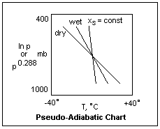 We have already seen that a plot of ln p against T is useful in analyzing radiosonde data. In the adiabatic chart, shown diagrammatically at the right, ln p is plotted on the ordinate, increasing downward, while T is plotted on the abscissa. It is clear that any state can be plotted on this graph. The dry adiabats are nearly, but not quite, straight lines. If we use p0.288 instead of ln p as the ordinate, the dry adiabats will become straight lines, and the plot will appear very similar. However, we can no longer use it when we really need ln p for a graphical solution of a problem. This is a minor consideration, so most practial adiabatic diagrams use p0.288. When the wet adiabats are drawn, it is assumed that the condensed water is eliminated from the system, as in raindrops. This is sometimes true, but usually the condensed vapor hangs about as a cloud. The reason for this assumption is to make it easier to compute the wet adiabat, since it is not necessary to heat and cool the condensed water, which is present in different amounts in different parcels anyway. The wet adiabats under these assumptions are called pseudo-adiabats, and so the chart is called a pseudo-adiabatic chart. The approximation has little practical effect, and must merely be kept in mind.
Since a dry adiabatic is also a curve of S = constant, it would be convenient to plot S vs T instead of ln p vs T. Such a TS-diagram is very useful in thermodynamics, and its utility carries over to the present problem. Since S is a function of T and p, S = S(p,T), we can solve for p in terms of T and S, at least numerically, and draw lines of constant p on the TS diagram. In meteorology, the entropy is usually denoted by φ, and for an ideal gas is φ = cp ln T - R ln p, with an additive constant. Absolute entropy is not needed here, so the value of the constant is immaterial. A reference state is usually chosen in which φ is assumed to be zero when φ must be plotted or tabulated. It is only necessary to realize that φ is just a certain function of p and T. Area in a TS diagram is equal to net work done by a system in a cyclic process, which is equal to the net heat absorbed, of course.
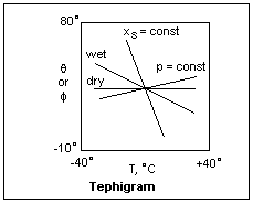 φ can be written φ = cp ln[TpR/cp], making it clear that for a dry adiabatic process, φ = constant. It is usual to determine the additive constant by defining θ = T(1000/p)0.288, where p is in mb. θ is just the temperature that a parcel of dry air would assume if compressed to 1000 mb, and is called the potential temperature of the parcel. It is obviously not changed in an adiabatic process. Therefore, φ = cp ln θ, and so we can label the values of φ by the corresponding potential temperature. The diagram then has potential temperature as the ordinate, and ordinary temperature as the abscissa. This diagram is called a tephigram, from T-φ-gram, shown diagrammatically at the left. It is usually more convenient than the pseudo-adiabatic diagram, since the families of curves cross at larger angles. A dry adiabat is now a horizontal line. A wet adiabat slopes upward to the left, and a line of constant saturation mixing ratio is not far from vertical. The lines p = constant are curves sloping upwards to the right. All this assumes that potential temperature increases upwards, and temperature increases to the right.
Although it may be difficult to find pseudo-adiabatic charts and tephigrams for sale, an example from a text can be duplicated for use. It is easier to use a fairly large chart. Most problems with moist air can be solved very easily with these charts, and they will make clear many of the relationships between the variables. The reader is strongly encouraged to obtain the charts and use them.
The Wet Bulb
The absolute humidity of a sample can be determined by absorbing the air with a hygroscopic substance and determining the increase in weight, an easy and simple exercise in quantitative analysis. This is an inconvenient process in practice, but in principle is quite simple. Fibers that absorb water depending on the relative humidity can be used as a hygrometer, but the results are normally too inaccurate for technical use. There are also films whose electrical conductivity depends on the relative humidity and are more accurate and reproducible. In both these cases, there is an important temperature sensitivity that must be considered. Two methods giving reasonable accuracy are the dew-point apparatus, and the wet-bulb psychrometer.
The dew-point apparatus is a cooled mirror surface. The temperature at which condensation first forms is noted, and called the dew point. In this process, a sample of moist air is cooled until the vapor pressure of water becomes equal to the saturation vapor pressure, which can be determined from the temperature. This establishes the mixing ratio of the sample directly.
The wet-bulb psychrometer is a thermometer whose bulb is surrounded by a moistened wick. Air is blown by the bulb, either by swinging the thermometer in a circle, or by a fan. The evaporation of the water removes heat, and finally an equilibrium is reached at which the temperature of the wet bulb attains a minimum value that depends on the mixing ratio of the air blowing by it. If the air is saturated, no evaporation occurs, and the wet bulb remains at the ambient temperature, called the dry-bulb temperature. With dry air, the wet bulb reaches its absolute minimum temperature. This is an interesting and complex process worthy of being understood. Evaporative cooling is of considerable importance, both in air cooling and for our bodies, where the evaporation of sweat makes it possible to endure temperatures of 100°F, which otherwise would invariably be fatal.
As a first approximation, we might assume that the saturation vapor pressure at the wet-bulb temperature T' is equal to the vapor pressure in the air blowing by. This cannot be exact, for the air is cooled from its initial temperature T to the wet-bulb temperature T', and this requires the abstraction of some heat, which must be made up by evaporation from the wick. A heat balance for 1 g of air gives cp(T - T') = L(xsw - x), where xsw is the saturation mixing ratio, x the mixing ratio in the incident air, and L the latent heat per gram. Using x = εe/p, we can easily express this in the form e = esw - (pcp/εL)(T - T'), called the psychrometric equation. Since we know all the constants, this can be expressed in terms of the Celsius temperatures t and t' as e = esw - 0.000646p(t - t')(1 + t'/1167). This is very close to Regnault's formula, in which 0.000646 is 0.0006, and 1167 becomes 610, so the differences are insignificant. This formula agrees with observations, which is the best recommendation for its acceptance, though you may have some reservations about the derivation.
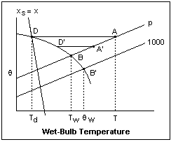 The tephigram can give some insight into what is taking place. The fact that the above derivation focussed on the air moving by the wet bulb is a kind of distraction. The important process involves the wet bulb alone, and the final result is the same no matter how the air passes by, just so long as it encourages evaporation. In the diagram at the right, A represents the initial air, at temperature T, pressure p, and mixing ratio x. If it is cooled adiabatically, its state follows the dry adiabat, a horizontal line, to the point D, where it intersects the saturation mixing ratio line for the value x, and at this point becomes saturated. The corresponding temperature, Td, is the dew point. The sample could become saturated in different ways, each with a corresponding dew point, but this is a standard definition giving a unique temperature. If the sample were cooled at constant pressure, it would become saturated at a slightly higher temperature, as can be seen from the plot.
The wet adiabat through D curves downward, intersecting the p line at B. This represents air that if cooled adiabatically, would wind up at D, and if then warmed would follow a dry adiabat to point A. This establishes a unique wet-bulb temperature Tw, if indeed the state of the wet bulb is represented by B. Another dry adiabat is drawn, connecting A' with D'; this is air with a different mixing ratio and temperature, but the wet-bulb temperature is the same. That is, the air leaving the wet bulb does not have to be saturated at the wet-bulb temperature, but eventually D' approaches D and stops there. The dry adiabat through A, the wet adiabat through D, and the saturation mixing ratio line for mixing ratio x, all intersect at one point, D. This should make the situation easier to understand, even if it is not a complete explanation.
Since we now know e from the wet-bulb temperature, and es at the dry-bulb temperature, the relative humidity f = e/es is quickly found. There are tables and charts to make this calculation easier, but they give no insight whatsoever, and seem like magic. It is not difficult to see that we can also perform the analysis on the tephigram. First we plot A and B on the pressure curve according to their temperatures. Then we draw a horizontal line through A, and follow the wet adiabat back from B until it intersects this horizontal line. Then we can read off the corresponding mixing ratio (which will be the mixing ratio at A), as well as the saturation mixing ratio at A, and divide them to get the relative humidity. The dew point can be read off as the temperature of point D.
Starting with the dew point, we plot A and the horizontal dry adiabat through it, then intersect with a vertical line at the dew point temperature to find D. This immediately gives the mixing ratio, and the relative humidity follows as above. Following the wet adiabat through D, we find the wet-bulb temperature at point B, if we need this. If the wet adiabat is followed further to the standard pressure of 1000 mb, the corresponding temperature is θw, the wet-bulb potential temperature. The 1000 mb isobar intersects the dry adiabat through A at the wet-bulb equivalent temperature, θe. These definitions are occasionally useful because they are independent of pressure.
The wet-bulb temperature is important in evaporative cooling. On test, my portable evaporative cooler blows out air at 21°C when the air temperature is 30°C, or 86°F down to 70°F, which corresponds to a humidity of 44%. This is quite satisfactory, as long as the cooler is supplied with hot, dry air, which is not a great problem here in July.
Stability of an Air Column
When a parcel of air is warmer than its surroundings, is it less dense and so lighter, and is buoyed upwards; that is, an upward force acts on it that tends to accelerate the parcel and transfer kinetic energy to it. On the other hand, when it is cooler, it is denser and heavier and tends to sink because of the net downward gravitational force on it, and not only may gain kinetic energy, but also transfers energy to its surroundings. All that is necessary to determine whether a parcel of air would rise or fall spontaneously is to know whether it is hotter or colder than its evironment.
An undisturbed parcel in equilibrium is at the same temperature as its environment, so it neither rises nor falls. If, by some means, the parcel is elevated a little, it expands adiabatically and cools a little. Whether it is then hotter or cooler than its environment depends on the lapse rate, which is determined by a variety of external events. If the temperature of the environment decreases at a faster rate than the temperature of the parcel, then the parcel winds up warmer, and there will be an upward force on it making it move even higher. This is the case of instability. On the other hand, if the environment cools less rapidly than the parcel with altitude, the parcel will find itself cooler and will sink back. This is called stability
Stability and instability depends on the relative rates of cooling of the environment and the parcel. If the parcel is unsaturated, it cools approximately at the dry adiabatic rate Γ of 9.8 K/km. If the parcel is saturated, then it cools as the slower wet adabatic rate Γ', which is variable, but amounts to 3-5 K/km. The parcel will take one of these two values, but the environment has a lapse rate of α. It is easy to see that if α is greater than Γ, the environment will cool more rapidly with height than any parcel of air, wet or dry, so the parcel will always find itself in unstable conditions. On the other hand, if α is less than Γ', the parcel will always find itself cooler than the enviroment if it rises a little, and so will be in stable conditions. If α is between Γ and Γ', some parcels will be stable, others will be unstable, depending on whether they are saturated or not. This is called conditional stability. We have already mentioned these considerations in connection with lapse rates above. This is local stability, which is always decided by a comparison of lapse rates.
It is more complicated when a complete air column from the surface up is considered. Now, the air at each height must be considered, as well as the stability of parcels moved from one level to another, not necessarily over a small distance. If the condition for stability is satisfed at all levels, then the air column is absolutely stable. If the condition for instability is satisfied at any one level, then the air column is unstable. We must consider the case when the stability is conditional, and examine all levels, since the property of unsaturation or saturation may change with altitude. The best way to do this is with a tephigram.
Before we talked mainly of T vs z; now we consider T as a function of p, which is fundamentally the same thing, except that the pressure decreases roughly exponentially with z. The result of, say, a radiosonde ascent can be plotted on the tephigram, and we get a curve sloping upwards to the left, since the temperature decreases with increasing height. In the tephigrams below, this curve will be plotted in red so it stands out. We can also plot the wet-bulb termperature as a function of height in a similar way, which brings the moisture content into the picture in a useful way. A given level is represented by a line parallel to the lines of constant pressure, and its intersections with the temperature curves give the temperature T and the wet-bulb temperature Tw at that level. The wet-bulb curve will, of course, lie to the left of the dry-bulb curve at all pressures when the air is unsaturated, and will coincide with it when the air is saturated.
On the tephigram, dry adiabatic process are represented by horizontal lines, while wet adiabatic processes are represented by curved lines concave downward and rising at lower temperatures. This makes it easy to compare any part of the dry-bulb curve with these processes to determine the local stability. If the dry-bulb curve is less steep than the wet adiabatic, then the air is absolutely stable. If it slopes downward to the left, which it can do, slightly, and be between a horizontal line and a constant-pressure line, a very steep lapse rate is indicated, and the air is absolutely unstable. In most cases, however, the dry-bulb curve will be intermediate in slope between the wet and dry adiabatics, and the stability will be conditional.
A green line will represent the T vs p behavior of the parcel of air under consideration. If the air is unsaturated, it will be horizontal, a dry adiabat, and if the air is saturated, it will follow a wet adiabatic. The parcel might not be brought to any particular pressure; this curve shows what would happen if it were. This way we can test a parcel originating at any height with the air in the whole column.
 In the tephigram at the right, the red curve ADE represents the state of the column of air, dry bulb temperature versus pressure. This is only a sketch tephigram; for quantitative results a proper tephigram is required. The point A represents the state of the air at 1000 mb, which we take as the surface. Point C is the wet-bulb temperature at this pressure. We see that the air is not saturated, since Tw is less than T. The lapse rate is between dry and wet adiabatic at A, so the stability is conditional. If we lift surface air, it follows a dry adiabatic from point A to point B on the wet adiabat through C. At point B it becomes saturated, and thereafter follows the wet adiabat, which appears in green. As far as point D, the parcel is cooler than the environment, and work proportional to the shaded area must be done on the parcel to lift it to D. Areas in a TS diagram are proportional to heat transfer, and if a cyclic process is considered the heat absorbed equals the work done.
At point D, the path of the parcel crosses the dry-bulb line, and then the parcel becomes warmer than the environment, and begins to rise spontaneously, so instability begins here. The environment now does work equal to the shaded area DE on the parcel. When the parcel reaches E, the buoyancy disappears, and it is once again heavier than the environment. This all means that if some surface air reaches level D, it then causes a release of energy and turbulence that may take the saturated air to great heights. This is, of course the chain of events in forming a cumulonimbus, when the initial step is the raising of moist surface air by turbulence above the LCL. If this is below D, then only cumulus humilis results. If it is above D, then a great deal of energy is released, and an enormous storm is created, with lots of kinetic energy.
The air column just described is said to possess latent instability. It is stable until certain motions trigger instability, by the mechanism we have described. In an actual analysis, one would also draw the wet-bulb curve, and consider air from different levels to see if they show latent instability. Latent instability occurs whenever the wet adiabats through the wet-bulb temperatures intersect the dry-bulb curve, as in this diagram. Often, real-latent-instability, in which the energy required to make the air unstable is much less than that released by the instability, is distinguished from pseudo-latent-instability in which the amount of energy required to bring the air to instability is greater than that made available from the instability. This is just a comparison of the energy areas in the tephigram.
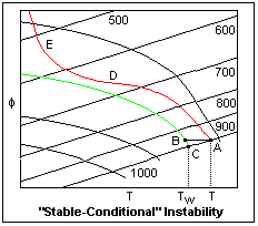 The figure at the left shows the same dry-bulb curve, but now the wet-bulb temperature at C is lower, due to less moisture in the surface air. The wet adiabat through the wet-bulb temperature never intersects the dry-bulb curve, so the air of the parcel is always cooler than the environment air, and the air column is stable. The lapse rate at A is still conditional, since it is not affected by the wet-bulb temperature. However, air at this level is invariably stable. The condition is called, rather clumsily, "stable conditional instability" when really there is nothing conditional or unstable about it at all. Note that we should test this at different levels. In this condition of the air, the wet adiabats through every point of the wet-bulb curve will not intersect the dry-bulb curve.
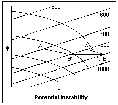 Another type of instability is shown in the diagram at the right. This does not refer to a parcel of air, but to a layer that may be relatively thin, but of wide lateral extent. This layer is considered to move bodily by atmospheric movements, which bring it to different heights. In the diagram, A and B denote conditions at the top and bottom of the layer, which is 100 mb in height, and is assumed to be unsaturated. The lapse rate AB is smaller than the dry adiabatic lapse rate, so the layer is stable at its initial height between 900 mb and 800 mb. Now let's suppose the layer is raised; the air at A and B will expand and cool adiabatically along the horizontal lines. For simplicity, let's suppose that the top and bottom (and presumably everything in between) saturates at A' and B', after a lift of 100 mb. Now the lapse rate A'B' is greater than the wet adiabatic lapse rate, so the layer is unstable. This, (for reasons not clear to me) is called potential instability. A lapse rate that was not unstable for dry air becomes unstable for wet air as a result of lifting. The lapse rate A'B' is nearly equal to the lapse rate of the wet-bulb curve, so the usual criterion for potential instability is that the lapse rate of the wet-bulb curve is greater than the wet adiabatic lapse rate. This is assured if there is latent instability. However, potential instability does not necessarily mean latent instability is present.
In this simple case, the whole layer became unstable at once; this is not the usual thing. Instability usually starts at the base of a layer, since the humidity is generally higher at lower altitudes, and so saturation starts there and proceeds upwards, more and more of the layer becoming unstable. Potential instability is caused by a change of lapse rate in a body of air due to raising that makes it greater than the wet adiabatic lapse rate.
The lapse rates are changed by the conduction of heat to or from hot or cold surfaces, by the addition or removal of moisture, by radiation, and by turbulence. Clouds, although white, are almost perfect black-body radiators, and the radiation from the upper surfaces of clouds can lower both wet- and dry-bulb temperatures (which are equal at saturation) and encourage instability. This is a primary cause of night thunderstorms. When air rises over mountains, instability can be caused by ascent alone. The same thing happens when warm air ascends at a warm front.
References
E. W. Hewson and R. W. Longley, Meteorology Theoretical and Applied (New York: John Wiley & Sons, 1944).
F. A. Berry, Jr., E. Bollay and N. R. Beers, eds., Handbook of Meteorology (New York: McGraw-Hill, 1945).
W. E. K. Middleton and A. F. Spilhaus, Meteorological Instruments, 3rd ed. (Toronto: University of Toronto Press, 1953). pp. 243-264.
Return to Weather Index
Composed by J. B. Calvert
Created 3 July 2003
Last revised 8 August 2003