Thunder and Lightning
Contents
- Introduction
- Clouds
- Electricity
- Thunder
- Curiosities
- Appendix: Humidity
- References
Introduction
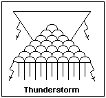 The thunderstorm is one of the best free shows available. It begins with a placid, sunny afternoon and ends in a dramatic finish with flashes of lightning, crashes of thunder, heavy rain, and perhaps a rattle of hail. Here in Denver, we have up to 40 such storms a year, chiefly in July and August, that begin on the mountain slopes to the west, and sail out onto the plains on the prevailing west wind, to end after midnight far to the east. The development can be observed quite conveniently in Denver over a couple of hours, perhaps from 2 to 4 in the afternoon, as the brilliantly sunlit clouds boil overhead. The Navajo pictogram for a thunderstorm is shown at the right. The cumulus, anvil, rain and lightning are all represented.
This article discusses some of the questions I have about these storms and their effects, and the lore I have accumulated. There are many experts in this field, of various degrees of reliability, and I refer the reader to their presentations, some of which are listed in the References. As with any natural phenomenon, thunderstorms are infinitely variable, so any description here is only of a typical storm, and does not include all the variations. It hardly needs to be said that not everything is known about thunderstorms and lightning, but the tendency of modern scientists to make up explanations of absolutely everything, and to hold to their prejudices tenaciously, is well illustrated in this field. Some of the explanations have been "geological" in being elaborately reasoned out on the basis of extensive research, but with total disregard for the actual behavior of matter and energy on this earth.
Clouds
The Sun heats the surface of the earth strongly, drying it out and making a layer of hot, humid air there. Since the atmosphere is heated from below and cooled from above, the air rapidly cools with height, at an average rate of perhaps 6.5°C per km (called the lapse rate), and the atmospheric pressure decreases rapidly as well. On these hot days, however, the temperature often decreases even more rapidly, and the lapse rate is often superadiabatic, meaning that it cools more rapidly than a rising parcel of air cools by expansion. Should a hot parcel of air rise a little, it finds itself a bit cooler, but still hotter than the air around it, so it is buoyed up higher, and the same thing happens again. The hot, humid air at the surface is convecting, driven by the buoyant forces of cool air that keeps coming in at the sides to equalize the pressure, while more hot air arrives from the surface.
This creates convective cells of rising hot air, surrounded by sinking cool air from above, as in water warming in a pot. These cells are not visible, but they are there everywhere over the hot ground. These bubbles rise and cool until finally they are cool enough that the pressure of the water vapor they contain is the same as the vapor pressure of a water drop. Then, with little excuse except some ions to nucleate upon, the moisture condenses out in fine droplets that are suspended in the rising air. A cloud has been formed, a modest cumulus humilis that billows up, showing the location of the convective cell at last. Its base is quite definite, at the "lifting condensation level" or LCL. A typical value for the LCL is 2 km, but it obviously varies a great deal with conditions. It can be 0.6-1.2 km in humid regions, up to 4.5 km in arid regions.
Condensation of the water releases the latent heat of vaporization, 540 cal/g, which heats the air and makes it lighter. Now we have a real drive for convection, much more powerful than the difference in adiabatic cooling rates. If there isn't a lot of water, this produces some mushrooming of the top of the cloud, but then the air is cooled by the surroundings, and things do not get out of hand. This shows that there is insufficient moisture to cause rain, so the day will probably be a fair one. The "humilis" in cumulus humulis means "low," and these fair-weather clouds remain wider than they are tall, and do not rise much more than 1 km above the LCL, to about 3 km altitude.
If there is more moisture present, the heat released by condensation may overpower the heat released by cooling, and the parcel begins to rise vigorously, bringing in wet air from below and the sides, creating an updraft that soon makes towers of billowing cloud. This stage is cumulus congestus, "congestus" meaning brought together. The hasty speed at which this proceeds is not apparent, unless you observe the same cloud for a while. The top is rising and expanding rapidly, and the cloud is joined by neighboring clouds, so that the products of many convective cells are combined. The clouds rise rapidly from 3 km to 7 km. The drops caught up in the rising drafts are cooled well below the freezing point, or supercooled, since with their limited mental capacity it is very hard to figure out how to arrange their molecules to form ice, which has to be made "just so." Apparently the formation and growth of ice crystals is required to initiate precipitation in these clouds, since only melted ice crystals are large enough to fall through the updrafts, the water droplets remaining small. If this takes place, then rain begins falling from the cloud, the large drops hitting the ground first because they fall faster. Even the normal drops are much larger than the average cloud particle, which never seems to grow sufficiently to make rain. Unless something special happens, the drought-parched farmer can watch many acre-feet of water simply drift over in a white heap.
The rapid rise of a cumulus congestus can push up moist air ahead of it (it's not the cloud pushing, but the rising air containing the cloud) and sometimes water will condense in an even layer, forming a pileus that looks like a smooth cap above the cloud. This is Latin for a cap of similar shape, and is worth looking for when you are watching clouds. It is another evidence of the rapid movement taking place.
It has been said that small droplets will evaporate in favor of large droplets, since the vapor pressure of a small drop is slightly larger than the vapor pressure of large drops. This proves that all clouds will rain, since the big drops will grow until they are heavy enough to fall. Since this is nonsense, there must be something else going on. There is: the small droplets are electrically charged, and this keeps them apart. The droplets must have the same charge, and the charge must be neutralized by ions of the opposite sign. More on this later. The fact that the vapor pressure of supercooled water is greater than that of ice probably does explain why once ice forms, the crystals grow quickly at the expense of water drops.
If things have got this far, they probably are out of hand, and the top of the cumulus congestus rises past 7 km and cools even further, until not even the supercooled droplets can resist freezing. This stage is called glaciation, which causes the previously sharply-defined billows of water droplets to become fuzzy and diffuse. Also, the top usually meets the point where the decrease in temperature ends, and the constant temperature of the stratosphere begins, the tropopause, at 10-15 km in these mid-latitudes. This closes the door abruptly on convection, and the top of the cloud can go no farther. The rising currents now spread out, and combined with the glaciation, form the typical incus, or anvil, of the cumulonimbus or thunderhead. Nimbus is just a common Latin word for a cloud, but also of one that makes a shower of rain. The essential thing about a cumulonimbus is that it is a congestus whose upward progress has been terminated by the tropopause.
Measurements of the water content of the cloud types we have mentioned were made in New Jersey and Florida, and gave 1-3 g/m3 for cumulus humilis, 2-6.6 g/m3 for congestus, and 2.5-10 g/m3 for cumulonimbus. Of course, this does not mean that the water content of a cloud increases as a storm develops, but that this is the amount of water required to reach each final stage. There is no more water in a cloud than in the clear air from which it was formed. At least 1.6 g/cm3 seems to be required for a cloud to produce any precipitation at all. Although the formation of ice crystals may initiate precipitation in the clouds we are concerned with here, they probably are not necessary in other cases, since warm clouds are known to produce rain. For more information on humidity, see the Appendix.
To make a thunderstorm, then, requires only moist, unstable air. Convective thunderstorms arise as just described, depending on sufficient moisture in the lower air, strong surface heating, and the large lapse rate typical after a clear, summer night. These follow almost a fixed schedule of development, taking a couple of hours between cumulus humilis and cumulonimbus, then rainbows and clearing from the west before sunset. Frontal thunderstorms, a distinct class, arise when the cold air at a cold front pushes up warm, moist air ahead of it, which cools and condenses the water in it, releasing heat that drives convection and makes cumulonimbus. A squall line is formed that moves forward with the front.
 The precipitation from a cumulus congestus or cumulonimbus may fall into hot air, where it evaporates before striking the ground. This may happen especially where a cloud is carried to the cold heights by a rising wind, as over a mountain, where it precipitates although the air below it is too dry to support much convection. This is now quite often termed virga in the United States, where it is of frequent occurrence. In Latin, virga is a green twig, a rod, or more particularly, a broom (once made by tying twigs to a handle). It is feminine singular, so what you see under clouds should really be virgae. However, it looks like a neuter plural, and this seems to be what the weather presenters think it is. Weather symbols for the various kinds of clouds discussed here are shown at the right.
Convection can also be driven by cooling from above as well as by heating from below. However, if it is the cloud that is cooling by radiating into space at night, convection would be hindered, since it would make the cloud material relatively heavier. It must be the atmosphere surrounding the cloud tops that cools by radiation, making the cloud material more buoyant. This drive can support thunderstorms into the night, but does not seem to create them unless the warm, moist air is already present.
The high, ice-crystal anvils of thunderheads can be blown away from the main cloud. As the crystals melt and evaporate, the cloud cools to a more normal temperature for that altitude, and the underside of the cloud begins to sink, becoming clearly defined, and sagging in huge bags, called cumulus mammatus. This cloud is a clear sign that there may be active weather in the vicinity, though by itself it is the result of active weather just past.
Electricity
 There is no doubt that electricity is a characteristic part of thunderstorms, as determined by Benjamin Franklin. The electrical makeup of a cumulonimbus is shown at the left in schematic form. The center of the positive charge P is in the upper, icy part of the cloud, while an approximately equal negative charge has its center N in the lower reaches. These charges are typically as large as 40C, a very large charge, and one that can exert large forces. A typical dipole moment, if these charges are considered to be 5 km apart, is 6 x 10¹⁶ esu-cm, pointed upwards, at a height of about 6 km. These are unbalanced charges and the regions tend to expand because of the mutual repulsion of the individual charges that compose them. There is sometimes a smaller positive charge p near the base of the cloud. This charge sometimes comes down in the first rainfall from the cloud. These charges would all attract one another strongly, and must be kept apart by some continuously acting mechanism. That is, conditions are dynamic, not static. The strong vertical updrafts, which probably play an important role in this, are represented by arrows in the diagram.
The preponderant negative charge N attracts a positive charge on the earth below the cloud, repelling electrons from the region that constitute earth currents generally directed towards the point under the cloud. A sharp metallic point will produce large potential gradients near its tip, perhaps creating a corona discharge that sucks electrons out of the surrounding air molecules to neutralize the positive charge. Such a lightning arrester can discharge the surrounding area if it is properly grounded, reducing the general electric field in the vicinity. It can also be a good place to begin a positive streamer upwards to meet a lightning leader, so it is best for it to be well-grounded. A lightning discharge will create large earth currents in the immediate neighborhood, which actually do most of the damage.
The most important question is how these charges are produced and maintained. A frequent explanation these days is that when a water drop freezes, it freezes partially, with the ice part being positively charged and the water part negatively charged. Then the water drops off, and, presto, we have charges. Aside from being ridiculous, this explanation does not treat the really important part, which is how the charges are separated. It will take energy to do this, and motion. I suppose this explanation was formed after the observation that the ice part of the cloud is near the P region, and the water part near the N region. Perhaps I have not done justice to it, since I have only read what others have said about it, but it is an extremely unsatisfying story.
 However, I might offer some suggestions towards a better explanation. The condensed water is an aerosol, and as in all aerosols, the colloidal water particles are charged. They form around ions, and since all are alike, they form around ions of the same charge, which we will assume to be negative. There must be positive ions of some type to neutralize the charge. These little drops can grow by coalescence with other droplets they encounter. If two drops of equal size coalesce, the electrical energy is reduced by about 21%, and surface tension also helps. The charge is preserved in this process to some degree. When the drops become large enough, they begin to fall, leaving the positive ions, or whatever, behind, high in the cloud. This initial charge separation produces an electric field, and now this electric field, combined with gravity, can amplify the charges. Note that this puts the P region above the N region, as is observed.
In the Kelvin water dropper, illustrated at the right, considerable electrostatic charges are built up by a simple mechanism. A water droplet is exposed to an electric field as it is formed, and the charge induced on it is trapped on it when the drop breaks off. Gravity pulls the drop against electrical forces into a receiver, where the charge accumulates on the outside of the metallic cup. The drops on alternate sides are oppositely charged, each using the potential of the other cup to induce the proper sign of charge. A very small random charge is all that is required to start the cooperative process. This device works really well, and is not hard to build at home.
A growing water droplet in the cloud dipole region will have a negative charge on its upper part, a positive charge on its lower part. If this droplet is blown into two by the updraft or collision with another droplet, the two charges will separate. If the positive droplet happens to be smaller than the negative, then the updraft may overcome the electrical force on it, as gravity overcomes the electrical force on the negative droplet, and the positive charge will be blown high in the cloud while the negative will fall towards the base. The regenerative charge generation mechanism may not be required, but it would certainly help to build up the charges.
Electrical discharges occur through the atmosphere between the P and N regions of a cloud, between two clouds, and, of course, between cloud and ground. The most is known about this latter discharge, since its path is mostly visible, while the others are hidden. There are even discharges between the tops of a thundercloud and the ionosphere, which were suspected for years, but now have been definitely identified. The mechanism of breakdown between two regions kilometers apart seems quite different from breakdown in the laboratory, but the processes are essentially the same, differing only in scale.
For cloud-to-ground strikes, which make up perhaps 20% of all lightning discharges, the process usually starts at the edge of the N region where the local field is great enough to enable the electrons to ionize air molecules, which is happening all the time, in which electron avalanches create a quiet, nonluminous Townsend discharge. If the field is a little stronger, a self-sustaining pulse of ionization, like the beginning of a corona discharge, takes place and a luminous finger of plasma darts forward until it is stopped by the weakening of the field. Then, the copious electrons at the beginning of the discharge fill out the conducting path and cause the field to strengthen at the head of the discharge. The light radiated from the discharge ionizes molecules around the head of the discharge, making the establishment of a path easier. With the field re-established, the discharge chooses one of these directions and darts forward again. The narrow path of the discharge exits the cloud and becomes visible below it. The path is irregular because of the random choice of direction at each step, and may even branch. This is called the stepped leader. It is moderately luminous, but not greatly so, and moves in the direction of the field a few metres at a time. The head of the discharge is brighter than the narrow conducting path behind it where electrons arrive to charge the path to a high negative potential. The current in the stepped leader is on the order of a hundred amperes.
The field between the header and the ground becomes stronger as the distance decreases, and usually a positive discharge, with the electrons leaving its base, comes up to meet it. When the two columns join, there is suddenly a conducting path between the N region in the cloud and the positively charged earth, with perhaps a million volts potential difference. Now the main stroke occurs, with kiloamperes of current, neutralizing the potential difference, and heating the conducting path to thousands of K. This, in effect, discharges the capacitor whose plates are part of the N region, and the earth, through the inductance of the filamentary conducting path. If there is still energy to be discharged, a new probe may search its way out of the N region towards the earth, using the previous path if not too much time has elapsed and the ionization has decayed. When this dart leader, which moves much faster than the previous stepped leader that was exploring virgin territory, reaches the earth, it is followed by another main stroke. This may be repeated several times. There is one case where 26 successive strokes were counted. If a second or so has elapsed, however, a new stepped leader must discover a new path.
A similar process occurs for intracloud and cloud-to-cloud strokes, where usually the electron-rich N regions initiate the leaders. Apparently, there can be positive leaders as well, originating in the P regions, but the negative leaders seem to predominate. The usual lightning stroke lowers coulombs of negative charge to the ground.
The observed fields in thunderclouds appear to be too weak to produce electrical discharges in the usual way. The recent observation of X-rays associated with lightning suggests a different mechanism, runaway electron breakdown. The mean free path of an electron decreases with increasing energy, reaching a maximum at about 1 MeV. With such long mean free paths, even a modest field can accelerate electrons to large energies. These fast electrons can create new fast electrons by collisions with atoms, and produce an avalanche. The problem then becomes the explanation of the origin of the fast electrons that can trigger such an avalanche, since the usual fields cannot produce them. Cosmic rays have been suggested as lightning triggers.
St. Elmo's Fire, a corona discharge at the ends of a ship's masts and spars, is evidence of large potential gradients under thunderheads.
Thunder
The heated air in the conducting channel expands violently and abruptly, to a pressure of about 10 atm, creating a cylindrical shock wave that decays into a sound wave at a distance of a few metres from the lightning channel. The sound that is observed depends on the distance from the stroke. Close to the stroke, the powerful result of the shock wave is heard, which makes a sharp bang of disconcerting strength, a "thunderclap." Farther away, this clap passes over our heads due to refraction by the lapse rate, and we hear the sound from the length of the channel, which arrives according to its distance from us. The result is a rumble or roll lasting several seconds. Acoustic radiation from the cylindrical channel is predominantly at right angles to the channel.
In addition to the audible sound, which has a spectral maximum at about 100 Hz, there is also an infrasonic signal of equivalent strength, down to periods of about 1 second. The main influence on the received sound is refraction in the atmosphere. Since the air is cooler above, sound travels more slowly there. A vertical wavefront will be retarded in its upper parts relative to its lower parts, and since the energy travels normally to the wavefronts, it will tend to rise. It is generally said that thunder is not audible beyond 25 km (16 miles), which is largely due to this effect. The speed of sound at normal temperatures is roughly 1000 ft/s or 340 m/s, so that by timing the interval between lightning and thunder one can estimate the distance of the lightning stroke. This is a very well-known experiment that was the first one used for the accurate determination of the speed of sound in the 17th century.
There is very little true absorption of sound in the atmosphere at acoustic frequencies and below, so one should use care in blaming anything on it. Scattering is a primary way a high-frequency beam of sound is attenuated, not absorption. Whatever high frequencies may initially exist in thunder are chiefly lost in this way, not by absorption in the atmosphere. Porous surfaces can, however, be good absorbers of sound, again at high frequencies.
Curiosities
Ball lightning or Kugelblitz has repeatedly been reported, but never explained, and there are apparently no photographs. This seems to be luminous red, yellow or white spheres about 15 cm in diameter that float or bounce about for a few seconds, then disappear in a puff. They seem to be hot, and can do damage. They are observed after lightning strokes in the vicinity, not at random. Similar phenomena seem to have occurred in circuit breakers and other electrical apparatus. There is an extensive literature on this subject; see Uman.
Lightning without thunder is called heat lightning or wildfire, and is usually intracloud or cloud-to-cloud discharges at altitude. It occurs on warm evenings in humid regions where the lapse rate is large, so that most of the thunder is directed upwards and does not reach the ground. It was the large lapse rate that produced all the clouds. If extensive, it is dramatic and beautiful, illuminating broad areas of cloud in flashes, sometimes behind dark obscuring cloud screens.
If a person is actually struck by lightning, it would more or less fry him to a crisp. Most reported cases, and all those where the person survived, are the result of a strike in the vicinity, where the large earth currents caused the injury. A lightning strike involves an extensive area, and one is only safe if inside a conducting shell, such as an automobile, or under water. The earth currents avoid depressions to some degree, so a ditch may be of some service. Lightning is actually a significant hazard, and steps should be taken not to meet it in the open. Tornadoes, on the other hand, are more localized and harm relatively few people by comparison, and are hardly to be feared, since you can see them coming. The weather phenomenon causing the most fatalities is neither: summer hot spells are the most deadly, statistically speaking.
The nature of thunder, which seems so clear to us, was actually deciphered at a fairly late date. In the 19th century, many held that the lightning bored a hole in the air, and thunder was the air filling that vacuum. Ridiculous, said others: the electricity actually electrolyzed water to hydrogen and oxygen, which then exploded and produced the thunder. Hirn actually came up with the correct answer is 1888, but was not believed for a while. As late as 1903, it was proposed that thunder was a "steam explosion" produced by the discharge. Although the ancients knew well that light travelled more swiftly than sound, the explanations were more along the line of clouds colliding or ejecting gases when compressed. The concept of clouds as solid bodies seems to be held by many today, if unconsciously, but most people have flown through them by now and know what they are like inside.
The recent drought in Colorado has brought out old ideas for creating additional rain to provide snow for skiing and other less important uses. The enthusiasts for cloud seeding with silver iodide are always brought to life again in such conditions, and it seems that several areas are to have the advantage of extra ions. Past experience shows that, as a means of getting extra rain, cloud seeding is not any better than a rain dance. It does seem to help in inhibiting the formation of hail, allowing clouds to precipitate before generating damaging hailstones, but not in increasing the total amount of rainfall. Enthusiasts work on the principle that if you seed the clouds and get rain, advertise it. If you seed the clouds and get less rain, forget about it. It is very difficult to get the statistics necessary to show that there is a beneficial effect. There is always a beneficial effect to the enthusiasts, however, since they get paid for it. Ions are only one factor in rainfall, and not the most important one. Besides, dusty western air is full of ions.
Most thunderstorms occur in the equatorial regions of South America, Africa and Indonesia, in every month of the year. There may be 50,000 thunderstorms each day across the world, with 2,000 going on at any moment. They play a significant role in the electrical balance of the earth and ionosphere. In the United States, thunderstorms are mainly a summer occurrence, with the largest number across the southeast, and especially in Florida, where they may happen on 90 days in the year. There are few thunderstorms on the West Coast. In summer, there is a wide band just east of the Rockies, centered in Colorado. The maximum thunderstorm frequency in this region occurs in northeastern New Mexico, where there may be 60 a year, the largest frequency outside of the southeast.
Appendix: Humidity
The water vapor content of air is its humidity. It is a good enough approximation in meteorology to treat both air and water vapor as ideal gases, which independenly occupy the same volume, and the total pressure is the sum of the partial pressures of air and water vapor, which are in temperature equilibrium. The absolute humidity is simply the mass of water in a given volume of air, or just the density of water vapor at the temperature considered. This may be given in g/m3, or in grains/ft3. 7000 grains make an avoirdupois pound, incidentally. 1 grain/ft3 = 2.2955 g/m3. The mixing ratio w is the ratio of the density of water vapor to the density of dry air, and is dimensionless.
The vapor pressure of water is 760 mmHg at 100°C, which we call the boiling point since bubbles of vapor can form and expand freely in hot water at that temperature. At 20°C, p = 17.535 mmHg. The density of water vapor at this pressure is ρ = pM/RT, where p is the pressure, M the molecular weight of water (18 g), T is the absolute temperature in K, and R is the universal gas constant. One convenient value for R is 62,400 mmHg-cm3/gmol-K, and with its help we find ρ = 1.7255 x 10⁻⁵ g/cm3, or 17.255 g/m3.
The relative humidity r is the mass of water actually contained in a sample of moist air to the mass in the sample if the partial pressure of water vapor were equal to its value at that temperature, or 17.255 g/m3 if the temperature were 20°C. If the relative humidity is 50%, then a cubic meter of moist air would contain (0.50)(17.255) = 8.63 g of water. This is about the humidity required to produce cumulonimbus. The relative humidity can be measured by the psychrometer, comparing wet- and dry-bulb temperatures, by its effect on hygroscopic substances such as hairs, or by actually absorbing or freezing out the water and measuring its weight.
One often hears that "hot air holds more water than cold air." This is, of course, nonsense. Air doesn't hold water at all, it completely ignores it. It's just that the vapor pressure of water is higher at higher temperatures. Air at 100% relative humidity has just as much water in it at Denver as at Mobile, but our mixing ratio is a bit higher. Incidentally, the vapor pressure of ice is quite different from that of (supercooled) water, so below 0°C, the reference must be stated. The vapor pressure of water at -15°C is 1.436 mmHg, of ice, 1.241 mmHg. This doesn't matter much in daily life, but in meteorology supercooled water is very frequently met with.
References
J. D. Cobine, Gaseous Conductors (New York: Dover, 1958)
M. A. Uman, Lightning (New York: Dover, 1984)
J. R. Dwyer, A Bolt out of the Blue, Scientific American, May 2005, pp. 64-71. Runaway electron breakdown.
A. V. Gurevich and K. P. Zybin, Runaway Breakdown and the Mysteries of Lightining, Physics Today, May 2005, pp. 37-43.
Return to Weather Index
Composed by J. B. Calvert
Created 28 October 2002
Last revised 5 May 2005