Cloudwatching
Contents
- Introduction
- Cloud Physics and Cloud Types
- Fog
- Unusual Clouds
- A Day's Clouds
- References
Introduction
Clouds are not only beautiful to watch; they give useful information to the ground observer on the state of the atmosphere. Their infinite variety also excites the scholastic classifier, who yearns to assign names to their forms, though the understanding gained by this exercise is negligible. Nevertheless, there is an International Atlas of cloud forms, and an elaborate scheme of naming that can give rise to many pointless but interesting arguments and discussions. There was even an intent to establish a thoroughly inappropriate Linnean classification with genus and species, though there is absolutely no genetic constancy in cloud forms. Clouds do develop in time, but the successive forms have no genetic relation under the classification. The purpose of this article is to look at cloud forms from a physical perspective, and to try to clarify the meanings of clouds for meteorology and for the cloud admirer. The views are the author's own, but are drawn from the literature. For the accepted meanings and defining characteristics, the reader is referred to the References.
Cloud classification began with Lamarck in France and Howard in England. Luke Howard (1772-1864) distinguished cumulus, stratus, cirrus and nimbus in 1803 in a famous talk on "Cloud Modification," originating a Linnean-like cloud classification. This classification is still the basis of cloud nomenclature, and is a very useful distinction. J. B. de Lamarck (1744-1839), better known for an erroneous theory of inheritance, an inveterate classifier, put forward a classification based mainly on height, but it was quickly forgotten. A separation into low-level, mid-level ("alto-") and high-level ("cirro-") was established later, when Emilien Renou distinguished altocumulus and altostratus clouds in 1855. The distinction is made on weather maps, and is very prominent in current nomenclature, but is often misleading. The combination of the criteria of form and height yield 10 cloud "genera" as the classifiers maintain. Beyond this, things rapidly become complex and contentious.
The altitude of Denver is 1600 m, so we almost project into the level where alto- clouds occur. However, affairs near the surface are controlled mainly by surface temperature and turbulence, so bases of cumulus clouds seem to be at about the same height here as at lower elevations. On the other hand, alto- type clouds seem to occur at rather low heights above the surface in Denver, and this may be a real effect. The altitude may also help to increase the lapse rate, and encourage convection.
Clouds inhabit the troposphere, the layer of the atmosphere beginning at the surface, in which the temperature decreases about 6.5°C per km, and which is usually turbulently mixed. Most of the atmospheric water vapor is in this region, and, in fact, most of the atmosphere itself. At an altitude of about 11 km in mid-latitudes the temperature lapse ceases, and the nearly isothermal lower stratosphere begins, at a temperature of about -56°C and a pressure of 230 mb. This boundary is the tropopause. It is at about 8 km in polar regions, and 16 km in equatorial regions, with a discontinuity at the boundary of the tropics.
High clouds, the cirrus clouds, occur at altitudes of 6 - 11 km, the upper half of the troposphere. At 8 km, the pressure is about 350 mb and the temperature is -37°C, close to the limit for the existence of supercooled water. Mid-level clouds, the alto- varieties, occur from 2 - 6 km. The pressure at 4 km is about 600 mb, and the temperature is -11°C. Supercooled water droplets are the rule in this region, though ice can certainly occur. These clouds are very frequent, and give good clues to weather developments. Low clouds are at 0.1 - 2 km (fog, a low cloud, is on the surface). The pressure at 1 km is about 900 mb (at sea level) and the temperature is normally 9°C, so water droplets only can exist. The bases of cumulus and cumulonimbus may be at this level, but these are not low-level clouds (though classified as such on weather maps) but clouds of vertical development, which can span the entire troposphere.
When you observe clouds, it is important to view the sky as a whole, and over the course of time. Hourly observations will show how cloud develops, and demonstrate that clouds are constantly changing. An observation of a particular cloud at an instant of time can be misleading and uninformative. The time of day is important as well. At twilight, not only is the play of light and color very beautiful, but it often makes various layers stand out as the shadow of the horizon rises. It is very difficult to estimate absolute altitudes, but relative altitudes are more easily appreciated. If you know the upper winds, altitudes can be estimated by the apparent motion of clouds.
For cloud pictures, see the Internet link in the References. Cloud pictures are being added to this article as they are captured.
Cloud Physics and Cloud Types
Clouds are colloidal suspensions, or aerosols, of liquid water or solid ice particles in the atmosphere. They form when moist air becomes supersaturated, and dissolve when the air becomes unsaturated. The mere existence of a cloud tells us that the air within it is saturated. Clouds are persistent because the maximum droplet size that can be formed is about 200 μm in diameter, which is still colloidal, and because electrostatic forces stabilize the aeosol. Ice crystals can grow large enough to precipitate at a rate such that they can fall out of the clouds, as is very commonly seen in cirrus clouds. Occasionally, water drops can grow sufficiently to precipitate as drizzle. Rain, with droplets more than a millimeter in diameter, is usually the result of the melting of ice crystals falling through the 0°C isotherm and the growth of the resulting large droplets.
Clouds are white because they consist of transparent colloidal particles, which scatter light but do not absorb it. Similar whiteness occurs in snow, milk and titanium dioxide and other white pigments, which are dispersions of transparent crystals. The eye interprets variations in illumination as greys of varying darkness; a shaded cloud can appear black. This coloring--and white is a color, a visual perception, not a physical thing--is one of the most attractive aspects of clouds. Colored illumination, as in the twilight, can produce sublime effects. When color is seen in clouds that is not in the incident illumination, it is produced by refraction or diffraction, as in the rainbow, glory, corona and halo phenomena. Any color is definitely very significant and worth considering. A thick cloud diffusely reflects about 80% of the incident radiation, absorbs about 7%, and transmits 13%. Of course, these figures vary widely.
It is quite a different matter in the infrared. Since water and water vapor absorb in this region, snow and clouds become black, not white, and absorb and emit radiation as black bodies. Radiation from the tops of clouds encourages the instability that drives night thunderstorms.
Clouds appear so solid and permanent when seen at a distance that children were told in ancient times that thunder was caused by their collisions. Angels were supposed to sit on clouds for rest, and this is still often depicted in comic strips. However, this is an illusion, and a cloud is not the same from one moment to the next, but changes constantly in appearance and sometimes in type. Nevertheless, the permanence of clouds is a matter of interest, since it would seem that the drops would increase in size on coalescence with each other, so that every cloud would pretty soon disappear as rain. In fact, this does not happen, and the occurrence of rain is actually unusual and demands special causes. The constant flux and metamorphosis of clouds can be appreciated only with careful observation.
It is very useful to classify clouds according to whether they contain water droplets or ice crystals. Low clouds must be of water droplets, and high clouds may be of ice crystals, simply because of the difference in temperature. Water droplets can be greatly supercooled, and in the absence of ice condensation nuclei do not change readily to ice. The fibrous and silky appearance and indistinct boundaries of cirrus clouds are often ascribed to ice, but the absence of halos seems to indicate that they are still water droplets. Spontaneous crystallization in cirrus clouds, which is common, leads to rapidly growing ice crystals that precipitate out in the characteristic feathery columns of falling crystals, the "cirri" properly regarded. The cause of this is the lower vapor pressure of ice relative to supercooled water. If the crystals do not grow, because the vapor is exhausted, cirrostratus is the result, exhibiting strong halo phenomena. In some conditions, alto- clouds can also contain ice crystals, because the temperature is low enough, but here the usual absence of halos says this is rare. In fact, a cloud that shows halos often is defined as cirrostratus, while if it shows only coronae, it is called altostratus.
Water droplets condense on tiny nuclei of diameters 0.01μm to 0.1μm, called Aitken particles that are generally present in sufficient numbers to cause condensation at small supersaturation. Near the sea, these are usually NaCl, but inland CaSO4 or (NH4)2SO4 predominates. Large nuclei are from 0.1 &mu:m to 3 μm, and giant nuclei are from 3 μm and larger in diameter. Hygroscopic nuclei can even cause droplets to grow in undersaturated air, when the relative humidity reaches 75% or 80%. Sublimation, or freezing, nuclei are rarer, and the formation of ice on them much more difficult. Many of these seem to be clay minerals, and some are meteoritic dust. Usually, a film of supercooled water forms on the surface of the nucleus, in equilibrium with the vapor pressure of supercooled water droplets in the cloud. At a sufficiently low temperature, which is usually far below 0°C, the water film suddenly freezes, its vapor pressure dropping at the same time. Then, vapor distils from supercooled water drops to the ice crystal, which rapidly grows. Ice crystals do not appear to be limited in size as water droplets are, and can grow large enough to precipitate. Ice crystals can clump together by riming, eventually forming hailstones if strong updrafts keep them supported, or agglomerate and intiate rain by the Bergeron process (see below).
Natural freezing nuclei are quite various, but not always plentiful. Artificial supplementation of freezing nuclei, "cloud seeding," is by crystals such as AgI, whose hexagonal lattices resemble that of ice. Ice has c = 0.736 nm, a = 0.432 nm, while AgI has c = 0.749 nm and a = 0.458 nm, a misfit of less than 2%. Ice freezes on AgI at -4°C. Solid carbon dioxide can encourage freezing on unsuitable nuclei by lowering the temperature sufficiently. The aim of cloud seeding is to initiate the Bergeron process, and thereby to decrease hail formation and increase gross precipitation. Actual results are quite inconclusive. Most trials seem more effective than prayer, but there is very little economic return, if any. Many enthusiasts, among them certain ski areas, support cloud seeding, even though it seems little more effective than a Ute rain dance.
Turbulence and instability are reflected in the upward swelling of cloud material in the typical cauliflower pattern. The water vapor that has condensed in such material warms it and makes it light relative to its surroundings, and it is buoyed upwards according to Archimedes' Principle. This turbulent swelling is characteristic of cumulus ("heap") clouds, and is usually easy to identify. It is facilitated both by a large lapse rate (decrease in temperature with height) and high humidity. The edges of these water-droplet aerosols are always sharp and distinct as seen from the surface.
A very common kind of cloud development at Denver is the progression from a low cumulus to an impressive cumulonimbus storm, occurring when the upper air contains a reasonable amount of moisture, and the lapse rate is not small. The heating of the ground by morning sunlight causes warm parcels of air to rise and cool over some areas, and a compensating downward flow of cool air from above over others. This initiates the typical turbulence of the lower atmosphere that thoroughly mixes it on the average. When a parcel reaches a level where it is cool enough to become saturated--that is, where the vapor pressure of water is equal to the vapor pressure over liquid water--then water vapor condenses, releasing a large amount of heat that warms the parcel. This strengthens the vertical movement, and a cumulus heap is formed. A cloud occurs above each such "thermal" convective column, with clear spaces between where the air returns downward. The flat bottoms of the clouds, all at about the same level, show the uniformity of average conditions. Though these clouds appear placid and calm, a few minute's observation will show that they are actually in vigorous motion, some parts rising while others are dissipating. If the lapse rate is not especially large, and the supply of moisture not especially great, an equilibrium will be reached at this level. This cloud is cumulus humilis, or "fair-weather" cumulus. This is a rather poor use of Latin, since "humilis" means "low," which these clouds are not especially; what was intended was a meaning of "common."
The reason these clouds indicate fair weather is that although they occurred, they did not trigger runaway convection in the upper levels. The conditions of lapse rate and humidity may not be large enough to support any disturbance originating spontaneously, but when encouraged by convective bubbles from below, condensation and instability may be initiated. The cumulus now takes off at higher levels, forming towers and heaps of rapid growth. Adjoining clouds then join, making a larger and larger heap, and the cloud rises through the troposphere as warm, moist air from below is lifted. These clouds are cumulus congestus, or "heaped-together" cumulus. The base of the cloud is still distinct, and has become grey or dark because of the shading of sunlight by the growing thick cloud.
If there is sufficient water vapor, the convection may reach the tropopause, where the extremely stable isothermal stratosphere establishes a firm lid, though the cloud may penetrate somewhat. Even before this level is reached, the supercooled water droplets in the upper parts of the cloud can freeze, and water vapor crystallizes on crystallization nuclei. This is called glaciation, and is evident from the appearance of the upper cloud, which assumes the indefinite and fibrous appearance of an ice cloud (although the visible part is probably still water droplets). The ice grows and falls through the cloud, initiating rainfall as the large crystals move below the freezing isotherm, melt and form raindrops, which is called the Bergeron process. Rain, which can be strong, now falls from the base of the storm, and the cloud is called a cumulonimbus. Characteristic phenomena accompany the storm, such as the charge separation that produces lightning and the associated thunder, and hail, ice crystals that accrete when tossed by updrafts and are too large to melt when they finally escape. In fact, the cloud is usually called a thunderstorm for these reasons.
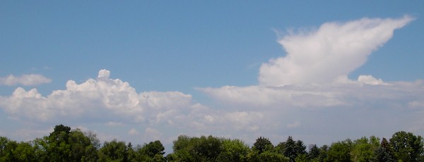 The photograph at the right shows convective clouds forming over the Rocky Mountain foothills west of Denver, about 60 km away. The time is 12.00 MST on 10 August 2003. The rest of the sky is clear, and the air is relatively dry. The large cloud at the right has a tower that has glaciated, and is being blown toward the observer by high winds of about 40 kt from the northwest. Surface winds are less than 10 kt, close to calm. At the left is a cumulus congestus, with convective towers. Here and there are patches of greyer altocumulus. These clouds are initiated by turbulence induced by solar radiation raising air to the lifting condensation level, which then triggers instability above that level. The patches of altocumulus are evidence of the instability. This same thing happens day after day. The largest of the cells of instability grow and are carried onto the plains to the east as powerful thunderstorms. It is notable that the clouds originate over the wooded foothills at about 9000' elevation, while there is no condensation over the hot plains to the east on days like this one, with the relative humidity at about 25%.
The initiation of rainfall by the melting of ice crystals is known as the Bergeron process, after Tor Bergeron, who conceived it in 1928, and published it in 1934. The Bergeron process competes with growth and coalescence of droplets in clouds above 0°C, which can created drizzle in nimbostratus, and rain in tropical convective storms. In middle and high latitudes, the Bergeron process is responsible for nearly all rain, but the role of competing processes is now recognized.
A cumulonimbus whose top has not begun to glaciate obviously is called calvus, "bald." When the glaciation is evident, the cloud is called capillatus, "hairy," from the fibrous appearance of its top. This cirrus is usually blown out to the side by stratospheric winds, forming an incus, an "anvil." Rain or hail is evidence that ice is forming somewhere in the upper reaches of the cloud. A roll cloud that forms in advance of a large cumulonimbus is called an arcus, an "arch." It is on the outer fringes of heavy precipitation, and the air is stable where the rising moist air blown out at the surface meets the condensation level. I am of the opinion that the evident fibrous "glaciation" is really just the stopping of condensation and evaporation processes and blowing of the droplets by wind, rather than the actual formation of ice crystals, unless they are seen to be precipitating, which is certainly often the case.
Sometimes parcels of air are strongly cooled by ice and hail, and, becoming heavy, tend to sink. This happens often on the underside of an extended anvil, and frequently at the base, of a well-developed and declining cumulonimbus. The dark bags that form add the term mammatus to the cloud name, because they resemble pendent breasts, or mammae. Meteorologists call them mamma, which is not a plural but a feminine singular, or even worse, mammata, a false Greek neuter plural. A similar thing happens to the word describing the broom-like appearance of precipitation that evaporates before reaching the surface, which is called virga, a "broom" or "twig." Again, this ought to be virgae, since virga is a feminine singular. Mammae are of frequent occurrence in tornado storms, but they occur after the danger is past.
Cumulus humilis and Cumulus congestus have the same standard abbreviation, Cu, but the cumulonimbus is signified by Cb (these letter abbreviations will be given for each cloud type below). The weather map symbols for these clouds (and for the others in this article) can be found in Weather Maps. The horizontal cloud base is characteristic, showing the connection to surface convection. The height of this base depends on local conditions, but is usually 1 km or less, though never on the surface. Since the whole cloud is often 10 to 12 km thick, any classification by "level" is specious. Cumulus and cumulonimbus may evolve into other cloud types as they dissolve, of every level classification. The upper, icy parts become cirrus nothus, or hybrid cirrus. The middle parts may form altostratus or altocumulus, while the lower parts may coalesce into stratocumulus or even stratus.
In the absence of turbulence and convection, a layer of moist air that is cooled by some means, usually by rising and the resulting adiabatic cooling, can become saturated, and cloud may form. The resulting cloud has no cumulus-like billowings, and is usually uniform. This kind of cloud is Luke Howard's stratus, which means "strewn, scattered" but implies the state of the scattered material, which forms a layer. Although the cloudless atmosphere does not absorb or emit much radiation, a cloud has a high emissivity and can exchange energy readily by this means. A stratus layer, once formed, can cool and thicken by radiation. Stratus can occur at any level, notably at the surface, where it is called fog, and hardly considered to be a cloud at all. However, a thick fog shows one what it is like to be inside a cloud, and there is no difference between fogs and clouds except that a fog is on or near the surface.
Simple stratus, St, is a low cloud, that can merge into fog. It is created as such by the same processes that produce fog at the surface. If conditions allow the droplets to grow to supercolloidal dimensions, they may precipitate slowly, producing the drizzle from a nimbostratus, Ns, a stratus, often with a diffuse lower surface, that is producing precipitation. Seldom does the drizzle become rain, where the droplets are evident to the eye. In a fog, larger droplets produces a wet fog. Any stratus that is producing precipitation is likely to be called a nimbostratus, whatever its origin and height, and if it is raining, the cloud is likely to contain embedded cumulonimbus and be of large vertical extent. Most nimbostratus comes from altocumulus that has thickened and merged together, often in association with cumulonimbus. The drizzle, at least in Denver, does not reach the ground in dry air. Heavy rain, if it occurs at all, comes from the embedded cumulonimbus or other sources of the ice crystals for the Bergeron process.
Unlike cumulus, stratus is vertically challenged and can easily be classified by altitude (except for the raining Ns just described). When the driving force for cumulus has dissipated, it is normal for the cumulus to spread and even coalesce, forming stratus-like layers. There are no longer distinct convective cells to separate individual clouds by blue sky. The result is stratocumulus, Sc, in which some of the lumpy structure still remains. The level bases are gone, however, and there is never any rain. Because cumulus is common, so is stratocumulus, usually later in the day. In fact, stratocumulus vesperalis, "evening stratocumulus," is a recognized cloud name. Stratocumulus may be thick, opacus, or thin, translucidus, but this condition is purely accidental and has no physical significance. Color and halos are never seen in stratocumulus (by definition). Stratocumulus may be considered as a decay product of cumulus.
Fractostratus, Fs, is stratus or nimbostratus that has been torn by the wind, or which has formed only in shreds and tatters. It is also called scud, a nautical term for sailing before the wind, or pannus, Latin for a rag or cloth. It is typical of bad (rainy and stormy) weather, and is usually quite low. Sometimes it forms independently, and stratus or nimbostratus can be seen through the gaps. A fractocumulus is cumulus torn into small shreds by the wind; it is normally higher, but is still not very high.
Altostratus, As, does not come from cumulus, but forms as such in an uplifted sheet of moist air, or when upper-level instability is triggered. It can be a thin layer through which sun or moon can be clearly distinguished, called translucidus, as frequently in the case of cumulostratus (altostratus formed by decay of cumulus), or thick, when sun and moon appear as brighter patches, and is called opacus, but is never as thick as thick stratocumulus. It may even rain--actually drizzle or snow--and be called praecipitans. Altostratus is high enough for ice to form, and may show the typical fibrous structure, which is usually a determining factor. Although it gives coronas, halo phenomena do not occur with altostratus (by definition). If halos are seen, it is cirrostratus.
A rising cumulus may lift the air above it, and an altostratus cloud may form in the lifted air, of a typically thin, cap-like disc; sometimes more than one will be stacked vertically in different layers of air. This fairly rare cloud is called pileus, after the Latin for a cap of similar appearance.
Cirrostratus, Cs, is similar to altostratus, but is higher and thinner. It may be a thin haze, called nebulosus that is scarcely distinguishable, but distinctly gives the halo phenomena. If no halos are seen, the cloud is altostratus and does not contain ice crystals. Alternatively, it may exhibit fibrous structure as filosus. The distinguishing characteristic of cirrostratus is its general covering of large patches of the sky. Cirrostratus and altostratus are seen in advance of warm fronts in the uplifted warm, moist air, and are, therefore, indicative of stormy frontal weather.
The clouds classified as altocumulus, Ac, are a very interesting and varied family. They are formed in upper-level instability, and so have cumulus forms. They are often low enough not to have frozen, though the water is supercooled, and so may lack cirrus characteristics entirely. On the other hand, streams of ice crystals may precipitate below them if active freezing is taking place. They may be called translucidus and opacus, depending on their thickness, but this is of little significance, except in appearance. Their cumulus heaps have no flat bottoms. A typical form looks like flocks of wool, and is called floccus. If the instability is strong, columns of rising condensing air may form, giving castellatus. It is very common for altocumulus to form from the upper reaches of dissipating cumulus, when it is called cumulogenitus, and is given a distinctive weather symbol. The wave clouds that form in the lee of mountains are usually classified as altocumulus lenticularis, because they are at a middle altitude and of limited extent. They might resemble lenses, but seldom lentils. They can look like flying saucers, and at times may have pileus caps. These clouds frequently exhibit corona colors, or irisations at their thin edges. Since the altitude of Denver is already 1600 m, altocumulus forms at what seems to be rather low levels, and is frequently seen in the evenings after a day of cumulus.
Mackerel sky is a pattern of small cloud tufts of approximately equal size, apparently arranged in a regular pattern, like fish scales. Altocumulus is the usual cloud type, but the sailor's term does not refer to any particular cloud type, but to an appearance. Cirrocumulus could probably give the same effect.
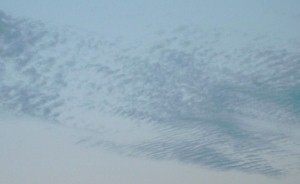 Altocumulus is the main cloud type of billow clouds at middle and high altitude, called altocumulus undulatus. An example is shown at the right, silhouetted against the eastern evening sky at sunset, and rapidly thinning. Another example is shown below, where there are two periodicities at an angle to each other, one of them at an unusually short wavelength. These clouds form in waves produced by flow instability in sheets of strong wind shear. The vertical amplitude of these waves is sufficient to cause moisture to condense at the higher levels, and to evaporate at the lower.
 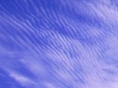 The air probably passes through stationary waves, creating the observed billows. It would be interesting to know what determines the wavelength. The term cumulus is quite appropriate, and we note that the condensation and evaporation would tend to drive the waves and maintain them in the face of frictional losses. Sometimes the wave sheets in altocumulus extend over extensive areas, often at different altitudes.
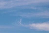 Clouds showing ice-crystal characteristics are called cirrus, Ci, Latin for "curl," describing the appearance of cirrus uncinus, "hook-shaped" cirrus. The photograph at the right shows typical morning cirrus at Denver, consisting of filosus and uncinus. Note the ice virga that resembles a cedilla on several neighboring clouds. The clouds producing it are being carried east (left) by strong winds, and the ice is falling into levels of less wind. Ice crystals are formed on sublimation nuclei at high altitude, and the falling crystals are blown horizontally by the wind, producing the sailor's mares' tails. Often, it is the cloud dropping the ice that is blown rapidly by the jet stream, and the ice falls into less rapidly moving air below. The ice usually evaporates at lower levels that are warmer and drier. These showers of ice are not permanent, but form and dissipate constantly. A thicker cloud shows fibrous structure, and is called filosus, shown in the photograph above. This is the most common kind of cirrus, usually sparse in an otherwise clear sky. The fibrous structure is usually much more discernible than in altostratus, and the cloud is thinner. If the cloud is thick, it is called densus. We have already mentioned a mixed kind of cirrus from the tops of cumulonimbus, nothus. I suspect that cirrus that is not precipitating ice is actually formed of supercooled water droplets, since I have not detected solar halos in such clouds, though I have looked carefully.
Cirrocumulus, Cc, is a relatively rare cloud type, perhaps produced by convective instability at a very high level, though turbulence probably plays a role. It usually forms from other cirrus clouds, and is nearly always associated with them. It is not at all common, though it gives the same weather indications as halos. I cannot determine from the references if cirrocumulus contains supercooled water, which it probably does. Cirrocumulus is very commonly undulatus, a billow cloud. The wavelength appears small because of the great height. This agrees very well with instability due to wind shear. There cannot be much difference between altocumulus and cirrocumulus except the associations.
Two rarer modifications of clouds are fumulus and radiatus. Fumulus means smoke-like, clouds of indefinite limits that form and dissipate rapidly, not to be confused with fractus. It is a rare term, restricted to lower clouds. Cirrus clouds may form long parallel lines, which by perspective seem to converge in the distance. Such clouds are called radiatus if this appearance is notable. Both these terms merely denote appearance, and are of no fundamental significance.
The interested observer should be able to recognize the 10 basic cloud types that have been discussed above. These are: cirrus, cirrostratus, cirrocumulus, altocumulus, altostratus, stratocumulus, stratus, nimbostratus, cumulus and cumulonimbus. Each gives clues to the state of the atmosphere, and the types grade into one another. Looking at cloud photographs, of which there are many in the References, is second in value only to observing the clouds themselves in acquiring familiarity with them.
Fog
A fog is simply a cloud on the ground. It is conventionally defined as occurring when the visibility is 1000 m or less. Lesser turbidity is usually called haze. Since the air is usually stable when a fog occurs, the cloud is a stratus cloud, and sometimes the base of the fog may lift, producing a low stratus. Two things are necessary for a fog: saturation and condensation nuclei. Saturation can be produced by the addition of water vapor, or by cooling. Fogs are classified by the way these conditions are created, and mixed causes are possible. Fogs are important in weather forecasting because of their effects on visibility, which is especially important for aircraft and shipping. Fogs are greatly influenced by the temperature gradient and turbulence near the surface. An inversion, a smaller decrease of temperature with height than the adiabatic rate, is usually required to keep the fog from dissipating rapidly due to convection, wind and turbulence. Fogs contain from 0.5g to 5g of liquid water per kg of air. The visibility in the air before fog forms may affect its occurrence, since haze may be an indicator of condensation nuclei, but the correlation is not pronounced.
On land, nocturnal cooling is usually very pronounced, especially with clear skies, so that a strong inversion and stable air is created close to the surface. Since turbulence is small, only a thin layer is cooled substantially. If this cooling takes the air below its dew point, water condenses, usually in the form of dew on cooler surfaces, especially in very stable, calm conditions. A thin ground fog can also form, less than a metre thick, if there is a little turbulent mixing. The increase in turbulence after sunrise, and an increase in the surface wind, can thicken the cooled layer and so the fog as well. However, the fog soon burns off as the earth is heated and turbulence destroys the inversion. Fogs produced by cooling attributed mostly to radiation are called radiation fogs, very common on land, when maritime air stagnates over a cool continent. Radiation fogs also form in mountain valleys due to nocturnal cooling. They do not, in general, form at sea because of the small diurnal variation of sea surface temperature.
A different case is the inversion fog, that occurs when a deep inversion is produced by subsiding warm, moist air over a relatively cool surface, such as the sea or land cooled by radiation. The top of the layer cools by radiation and turbulence, so a stratus cloud forms that builds downward. This may be met by ascending cool air that forms a thick fog layer from the surface to the inversion. If the wind is strong, however, turbulent mixing keeps the surface layers free of fog, so that there is a stratus deck at about 30 m or so. Inversion fog is seen on subtropical west coasts, as in Southern California.
The moist air can also be cooled by adiabatic ascent, as by light east winds on the eastern slopes of the Rocky Mountains. If the air is stable, an inversion is maintained that keeps the fog from blowing away. If the air is unstable or the winds strong, the condensation usually occurs at a higher level, with the formation of convective clouds instead of fog. These are upslope fogs. They should be distinguished from cumulus clouds simply being blown onto high stations. This is a fog for the high station, but simply a cloud for observers in the valley.
The most common fog at sea is the advection fog, created when warm, moist air moves over a cold sea surface. A moderate degree of mixing in a gentle wind can saturate the air in a thick blanket, producing dense fog. On the Grand Banks, Beaufort Force 3 is associated with maximum fog occurrence. Strong winds may casue the fog to lift slightly, as mentioned above. The warm air always produces an inversion, which holds the fog in. Advection fogs also occur on land, sometimes with sea and land breezes on coasts. Extensive and persistent advection fogs occur when moist tropical air moves over cold ocean currents. Tropical Pacific air moves over the Oyashio current off Kamchatka, and over the Bering Sea; similarly, tropical Atlantic air is cooled by the Labrador current off the Grand Banks. These summer fogs are probably the most extensive in the Northern hemisphere, at least. Advection fogs also form where there is upwelling of cold water, as off Southern California, Peru and southwest Africa.
All the fogs we have mentioned so far are caused by cooling of moist air. Saturation can also be reached by adding water vapor. One situation occurs in a warm front, where clouds in the uplifted warm air rain into the cold air beneath the front. The rain drops evaporate, and if they are initially warm enough, the air below is saturated and frontal fog forms. Note than an inversion is naturally present with the warm air aloft.
When moist air that has been over cooled land, so that an inversion has been formed, moves over warm water, the very moist air at the surface of the water may be lifted by turbulence and cooled at the moist adiabatic lapse rate. This condensation will produce a steam fog, held in by the remaining portion of the inversion above the zone of turbulence. Steam fog is rare at sea, but may occur in fjords and other inlets, and in the winter as arctic sea smoke. It is seen in winter over the hydrothermal features of Yellowstone, and other such areas. The fog that forms in bathrooms when a warm shower is used in cool air is also a steam fog on a small scale.
Fogs are rare over cold snow surfaces in polar regions, because of the desiccating effect of ice crystals on moist air. The lower vapor pressure of the ice crystals causes supercooled water vapor at the same temperature to condense, which both dissipates the fog and warms the ice. This is the mechanism that dries continental polar air masses. At temperatures from -20°C to -50°C ice crystal fogs can form on sublimation nuclei. Since the crystals in this fog have the same vapor pressure as the snow, ice crystal fogs are very persistent, because solar heating and convection are rare in these circumstances as well. Only a wind can blow them away.
In the U.S., dense fogs are prevalent on the west coast, occurring more than 40 days a year in the northwest, and 20 days a year in Southern California. They occur in the Great Lakes region in spring and autumn, and in the western slopes of the Appalachians from Pennsylvania to Georgia, with a maximum of up to 50 days a year in West Virginia. An area of very frequent fog begins off Nantucket Island, which is part of the fogs of the Labrador Current. In the intermountain region, from Montana to New Mexico, there are less than 5 foggy days a year.
Unusual Clouds
Sometimes fibrous, silvery white clouds are observed long after sunset in northern latitudes (45° to 80°, May to August, and also in the southern hemisphere during its summer), and are called noctilucent clouds, or "luminous night-clouds" because they are visible well into the night. Their illumination by the sun below the horizon (-6° to -12° is best) shows that they were very high, but other than this their nature and origin were only speculations of whether they were ice crystal or solid particle clouds, appealing first to volcanic dust, and then to cosmic dust. The mystery was solved in 1962, when a rocket brought back samples. The clouds occur only at around 83 km altitude, above where most meteors burn up, at the mesopause, far above the stratosphere, and consist of ice-coated meteoritic dust. The condensation nuclei are 50 to 500 nm in diameter, and the cloud particles 100 to 400 nm. At this level, the temperature is -108°C and the pressure only 7 μmHg. These clouds could not be supported by aerodynamic forces, it would appear, but are swept along by the winds, that approach 400 mph. The particles are extremely tiny and could be supported by Brownian motion instead. The mean free path there is about 6 mm. The ice comes from water that seasonally leaks into the stratosphere from the tropical discontinuity in the tropopause and is blown high by the fast winds in the very rare air.
Noctilucent clouds should be distinguished from the very different-appearing nacreous or "mother-of-pearl" clouds that are observed at about 25 km altitude near the stratopause, the top of the stratosphere, where the kinetic temperature begins to increase again. These are ice-crystal clouds, and the source of the water is probably the same as for the noctilucent clouds. Nacreous clouds are illuminated for up to 2 hours after sunset. They appear colored, and their light is polarized, so the color is at least partially due to refraction as well as to interference. Halos have been seen in nacreous clouds.
Vortexes are of frequent occurrence in the atmosphere, but they are usually invisible because of the transparency of air. They become visible when they blow around loose débris, agitate dust, or condense moisture. Strong convection, as occurs above a hot desert even when there is little moisture, draws air into an updraft, where the conservation of angular momentum changes a weak wind into a strong vortex with low pressure in its centre. These vortexes last as long as the supply of hot air lasts, and can be disposed of at altitude. They occur quite generally in hot weather, especially in cities where the hot concrete warms air efficiently, and can be seen swirling down alleys and streets. In the desert, they form dust devils that are visible because of the fine dust picked up. They rotate in either direction, though cyclonic motion is slightly favored.
Stronger vortexes can form in open areas where convection is active, as when cumulus is growing into cumulonimbus. Over the sea, where the air is saturated, a little adiabatic cooling as the air enters the central part of the vortex suffices to produce condensation. Then the core of the vertex fills with cloud, which usually reaches the cumulus above. The heat released tends to strengthen the vortex. This is a waterspout, of rather frequent and regular occurrence in favored locations. When a waterspout moves over land, the moist air feeding it is no longer available, and the vortex quickly dissipates.
Over land, a stronger vortex is necessary to collect enough moisture and angular momentum to sustain itself. Though the vortex begins like a dust devil, when it reaches a cloud it is easy to dispose of its contents, since the pressure in the core is equalized through the length of the vortex. Indeed, the vortex need not even begin at the ground, but at higher levels beneath the cloud if there is enough vertical motion there. Now the moisture in the low-pressure core of the vortex begins to condense visibly near the cloud, and as the vortex intensifies the condensation approaches the surface, giving the impression of a funnel descending from the cloud. However, as this happens, there is usually a wide area of dust and débris already circling near the ground. Finally, the condensation reaches the ground, and a tornado has formed. A cloud with a funnel cloud hanging beneath it is called tuba, from the Latin for a trumpet of similar shape. The pressure in the core of the tornado at the surface is approximately the pressure at the cloud base, as much as 70 mb less than the surface pressure, a very strong low indeed.
Tornados are of all strengths, from those typical of waterspouts up to strong storms composed of multiple vortexes, which revolve around one another scouring an area 100 m in diameter for weaker tornadoes, up to a kilometer or more. They are classified in the Fujita-Pearson scale from F0, with maximum winds of 116 kmph or less, up to F5, with winds approaching 500 kmph. The great majority of tornados (over 60%) are weak, F0 or F1, though these can still do local damage. Despite occasional disasters, tornados are not, overall, a great weather hazard because the areas affected are so small. Lightning is far more dangerous, and even hot weather causes many more deaths. Road accidents kill a thousand times as many people as tornadoes. A tornado that does not appear to be moving as it approaches you is very dangerous; if it appears to be moving, it will miss you. Tornados are easily outrun in a car, if you drive in the proper direction. Whatever you do, don't take shelter under a bridge, but in a ditch in the open. The chief hazard is flying débris. Tornados are not seen in many areas, such as from the Rocky Mountains west. Denver has no real tornados, but they can do serious damage less than 100 miles to the east. England would have tornados, but there is so little distance in which they can develop that strong tornados are very rare. There are, however, frequent waterspouts on the south coast.
Aircraft create cirrus clouds that seem always to be visible in the sky. These condensation trails are condensed engine exhaust released at typical altitudes for cirrus formation. Wingtips and propeller tips also produce low pressure in which moisture can condense. A vortex trail streams from each wingtip, rotating in opposite directions, providing the downwash that is a necessary consequence of the lift of the wings. The helical vapor trail could often be seen in moist air behind the propellers when the engine of an airplane was accelerated, as well as the wingtip vortexes in ordinary flight. These condensations can no doubt trigger condensation trails in moist air, but engine exhaust is a ready source of moisture. Contrails are a type of cirrocumulus, consisting of ice crystals in most cases, and exhibiting fibrous structure. In fact, I have observed bright patches that are parts of a halo. Other contrails precipitate ice like cirrus. Unlike most clouds, they are not beautiful or awesome, but only visual pollution. They can be seen even in satellite photographs of the earth.
The downwash may also penetrate thin clouds below an aircraft flying in dry air, causing the cloud to dissipate along the flight path. This phenomenon is called a distrail (dissipation trail), and is rather rare.
Any release of a large quantity of heat and moisture will cause a cumuliform cloud. A forest fire provides both heat and moisture, which can cause a cumulus cloud to form in and over the smoke of the fire, that can develop into a cumulonimbus with rain and lightning, either extinguishing or causing further fires. The cloud is called pyrocumulus. The appalling release of energy in a nuclear explosion creates an instant cumulonimbus, with a thick column of rising hot air that spreads out cauliflower-fashion when it reaches the tropopause, resulting in the familiar mushroom cloud, happily more seen in art than reality. There may be lightning, thunder and rain following soon after.
A Day's Clouds
As an example of cloud observation, hourly cloud reports are given here for Denver, Colorado on 6 July 2003. These are certainly not expert reports, but are simply an attempt to find out how this can be done. It is a very good exercise, and will convince you that this is not an easy task, nor one that can be accomplished without a good deal of experience. However, it is certainly not arduous. I simply observed the sky for about five minutes or less to get an impression of the clouds, and took brief notes.
6 July was a hot summer's day with a maximum temperature of 91°F. There was no wind, and no precipitation. A slow-moving low 1004 mb was over the eastern border of Colorado, and a high 1012 mb was forming in northern Arizona. A weak cold front approaching from the northwest disappeared over Wyoming. The barometer was changing very slowly if at all, at 29.95 inHg, where it had been for several days. The temperature and dew point were 31 and -2 at Cheyenne, and 35 and 10 at Pueblo (°C), so the air was quite dry. At 250 mb, the wind was 30 kt from WSW, and at 500 mb, 20 kt from WSW.
0900 MST: cirrus filosus and uncinus covering less than 1/10 of the sky.
1000 MST: cirrostratus film increasing; cumulus over foothills to west; altocumulus forming here and there.
1100 MST: altocumulus hiding sun, about 3/10 cloud cover.
1200 MST: heavy altocumulus to west, with cumulus embedded; cloud bases diffuse; cumulus congestus seen in distance to south, about 8/10 cloud cover.
1300 MST: altocumulus or stratocumulus cover 10/10.
1400 MST: large, dark mammatus just to east, but clear patches to west through which cirrus and altocumulus are seen.
1500 MST: stratocumulus or altocumulus broken, sun shining through clear areas, embedded cumulus, cloud edges more definite, 8/10 cover.
1600 MST: cumulonimbus calvus seen to east, prob. the earlier mammatus, altocumulus and stratocumulus becoming diffuse, 6/10 cover.
1700 MST: many open patches to east in thin stratocumulus; sun shining in west.
1800 MST: patchy altocumulus in east, 2/10 cover.
1900 MST: cirrus seen above patches of altocumulus in clear spots.
2000 MST: thick altocumulus covers sky; puffy lumps with thin places, 9/10 cover.
2100 MST: altostratus showing a few streaks of structure, more than 9/10 cover.
2200 MST: uniform layer clearing rapidly from northwest; wind Force 1.
2300 MST: clear sky, no clouds evident.
It is clear that the lower clouds formed as soon as the daytime turbulence was well-established, and dissipated as soon as the daytime turbulence ceased. Except in the few cumulus cells, the cloud was always thin, ice did not form, and there was no precipitation. The cirrus was distinct from the lower clouds.
References
Good cloud pictures are unexpectedly rare on the Internet. The best site I have seen is Plymouth State College from New Hampshire. There is a very nice Kelvin-Helmholtz instability wave, and excellent lenticular clouds.
F. A. Berry, Jr., E. Bollay and N. R. Beers, Handbook of Meteorology (New York: McGraw-Hill, 1945). pp. 882-926. pp. 915-926 contain the U.S. Weather Bureau Cloud Code Chart with photographs of 34 cloud forms with their map symbols.
U. S. Department of Commerce, Civil Aeronautics Administration, Pilots' Weather Handbook, CAA Technical Manual No. 104 (Washington, DC: Dept. of Commerce, 1955). There are surely later editions of this excellent handbook, which contains a lot on weather maps.
E. W. Hewson and R. W. Longley, Meteorology Theoretical and Applied (New York: John Wiley & Sons, 1944). An excellent general textbook of meteorology. A more recent text would be desirable, but there are not many of equivalent quality and readability.
V. J. Schaefer and J. A. Day, Peterson Field Guides: Atmosphere (Boston: Houghton Mifflin, 1981).
D. M. Ludlum, The Audubon Society Field Guide to North American Weather (New York: A. A. Knopf, 1991). Many color plates of clouds.
F. H. Ludlum and R. S. Scorer, Cloud Study: A Pictorial Guide (London: John Murray, 1957).
M. Minnaert, The Nature of Light and Colour in the Open Air (New York; Dover, 1954). Iridescent clouds, including nacreous clouds, are discussed on pp. 226-230. Noctilucent clouds are discussed on pp. 284-287.
R. K. Soberman, Noctilucent Clouds, Scientific American Magazine, June 1963. Description of the rocket flights that brought back samples in August 1962 from over northern Sweden.
H. R. Byers, Elements of Cloud Physics (Chicago: University of Chicago Press, 1965). Deals mainly with nucleation of ice and water, of importance in cloud seeding experiments, but rather dry material in general.
G. L. Stephens, The Useful Pursuit of Shadows, American Scientist, Sep-Oct 2003, pp. 442-449. Clouds in modern meteorology; clouds in art; history of cloud classification.
Return to Weather Index
Composed by J. B. Calvert
Created 5 July 2003
Last revised 12 August 2003