Weather Maps
The constantly changing weather is a fascinating study, to which maps are the key
Contents
- Introduction
- Weather Maps
Available Maps
Wind
Highs and Lows
Fronts
- Map Symbols for Weather and Clouds
Examples of Actual Station Symbols
- Looking at Weather Maps
The CWO Analysis Charts
The Denver Storm of 18 March 2003
Some Station Symbols from June 2003
From Equinox to Solstice
- References
Introduction
The purpose of this article is to introduce and explain the professional weather maps available on the internet, using as the model the analysis charts provided by the Meteorological Service of Canada/Service Météorologique du Canada (MSC/SMC), also known as the Canadian Weather Office (CWO). A link to this site, and others, is provided in the References. The reader should download a Mean Sea Level Pressure (MSLP) analysis chart from this site for reference while reading this article. To do this, click English or French in the first screen, then Weather Maps in the index, then Analysis Charts, and choose one of the Complete maps. Two scales are provided (165k and 90k). The 165k is better for detailed inspection, the 90k for archiving maps for comparison. These are the best maps I have found so far, and we should be grateful to MSC for making them available. We can obtain up-to-date, no-nonsense professional-grade information here at any time. One of the great pleasures of the present study is that it can involve current happenings, and you can look out your door at it.
An internet search for "weather" or "weather maps" will return over a million sites, most of which are useless. A search for "weather maps isobars" will eliminate a good deal of the rubbish, giving you only a few thousand sites. "Australia weather maps isobars" will also tighten the search. The US Weather Bureau is interested in selling stuff, not providing it as a service to the public, and their information seems inferior. Their web sites will get you .COM sites with cookies, porno, pop-up ads coming from nowhere, and such, so they are best avoided. There is apparently a lot of money in weather, a great number of children involved, and a lot of TV-weather-report trivia, which are of little interest to the intelligent. Some of the children's sites may be interesting as an introduction, but have little depth and at times are not too accurate.
Weather Maps
Available Maps
The weather map, analysis chart or synoptic chart shows isobars (contours of constant pressure), highs and lows (centers of maximum or minimum pressure), fronts (boundaries of air masses) and station data (wind, weather, cloud cover, cloud type, barometric pressure, temperature and precipitation). The amount of detail included depends on the scale of the map, but even a simple map contains a large amount of data. It takes considerable practice to understand a weather map, but the knowledge will come easily and will be very satisfying. By all means look out-of-doors at your own location and analyse what you see in terms of your map study. Particularly interesting is correlating the cloud forms with weather conditions. The kind of map that mainly concerns us gives actual measurements at some definite time in the past, not a prediction of future events, and is called an analysis chart.
The MSC maps are drawn on a conformal projection centred at the North Pole. They do not cover the complete Northern Hemisphere, but Canada and the US, Europe and Northern Siberia are included. Radial meridians are drawn every 10°, with tick marks at 1° intervals. Circular parallels of latitude are drawn every 10° with 1° ticks as well. This facilitates determining geographical coordinates for reference of feature location. Note also the outlines of the continents, provinces and states, which also help in orientation. The maps reflect past actual conditions at 00Z, 06Z, 12Z and 18Z, which are UCT (GMT, or Zulu time), the hour at Greenwich. For Denver, I subtract 7 hours, so they correspond to 17, 23, 5 and 11 hours MST. Updated maps appear not long after these times. By comparing two maps, the speed and direction of the motion of features can be estimated. Therefore, about 24 hours of history is always available. Satellite imagery, that shows cloud cover, is also available.
The British Met Office provides excellent weather maps of the United Kingdom area on the internet, including a GIF animation of recent history. There is also an isobar chart with superimposed satellite imagery that clearly shows the relation between clouds and fronts. This map is excellent because the satellite imagery does not dominate the image, and both components can be seen and compared.
Pressures on the Canadian maps are given in hPa, hectopascal, which is just a millibar (mb) by another name. The proper unit to use would be the kPa, kilopascal, and the metric police should investigate these weather people. Apparently the millibar sounded like an English unit, but it is as metric as the hectopascal. A bar is 106 dyne/cm2, and a millibar or hectopascal is 1000 dyne/cm2. Apparently the hectopascal is not entirely at home yet, since the MSC sometimes abbreviates it variously as Hpa, hpa or HPa. In weather study, the pressure is simply a useful number, and the actual pressure, as a force per unit area, is not required. The lowest authenticated sea-level atmospheric pressure was 886.7 mb, recorded on 18 August 1927 at sea east of the Philippines during a tropical storm, and the highest was 1075.2 mb at Irkutsk, Siberia on 14 January 1893. Extreme pressures that have been observed in the U.S. are 935.0 mb and 1059.6 mb. The standard atmospheric pressure is 1013.25 mb. Equivalent sea level pressures for inland stations are obtained by adding a correction to the observed pressure that depends on the altitude and the temperature (see References). At Denver, the correction amounts to 164 mb, 123 mmHg, or 4.85 in Hg at 70°F, and the actual pressure is about 850 mb. If you like to measure pressure by a mercury column, 1 mmHg = 1.333 mb, or 1 inHg = 33.9 mb. The standard contour interval on weather maps is 4 mb, which is easily divided by two or four. The most commonly seen heavy contours are 1000 mb, usually encircling lows, and 1024 mb, usually encircling highs.
There are upper-air maps for pressures of 850 mb, 700 mb, 500 mb and 250 mb. Normally, these pressures correspond to altitudes of 1.5 km (5000 ft), 3 km (10,000 ft), 5.5 km (18,000 ft) and 10 km (33,000 ft). Pressures could be contoured at these levels as they are at the surface, but this is not the way it is done. Instead, the contours are the heights of the corresponding constant-pressure surface. The heights are given in units of 10 metres, or dekametres, for some reason, so that 10,200 m comes out as 1020. The contour interval, at least on the 250 mb map, is 120 m. On the 500 mb map, the contours will be labelled 500 or so, corresponding to 5000 m elevation, which can be a little confusing at first sight. At 700 mb, the elevations are around 300 dkm, and at 850 mb about 150 dkm. 80% of the mass of the atmosphere is below the 200 mb level, which is at about the height of the tropopause.
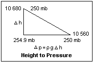 Using the 250 mb chart as an example, the height contours can provide pressure information if we use the aerostatic equation dp = -ρgdz. At this altitude, the density is about 4.16 x 10⁻³ g/cm3, and g is about 977 cm/s-2, so Δp(mb) = 0.04064Δh(m). The contour interval is 120 m, or 4.88 mb. An altitude high is a pressure high as well, and an altitude low is also a pressure low. An actual example of a height-to-pressure calculation is illustrated at the right.
The upper-air maps give additional information. The 700 mb and 850 mb maps give temperature contours, while the 500 mb map has contours of equal thickness of the layer 1000-500 mb. These additional contours are dashed. The thickness of the layer 1000-500 mb is an indication of its average temperature, a thicker layer being warmer. (It is lighter, and so a greater depth is necessary for the same pressure.) The 250 mb map also provides wind contours, and shades areas of different wind speeds. This, of course, picks out the jet stream, the most significant feature in temperate weather. When you want to know what the jet stream is doing, look at this map!
Temperature in the troposphere decreases with altitude, very roughly linearly although the rate is quite variable in the lower parts, below 3 km, say, and is affected by surface conditions. The dry adiabatic lapse rate is about 10°C per km, the standard average lapse rate is 6.5°C per km, and the wet adiabatic lapse rate is 3°-5°C per km. An inversion is a local and temporary increase in temperature with height, which can occur at low levels when the ground is cold and the air is warm. The temperature at the tropopause is, on the average, about 217K, or -56°C, and seems relatively constant. The station symbols on the 250 mb map give the temperature at that altitude, which is usually in the -50's. This would be the earth's temperature without the greenhouse effect that is due mainly to water vapor. The lapse rate is not given in weather maps, though it would be a valuable guide to the stability of the atmosphere. The stratosphere has a near-zero lapse rate, so convection is strongly suppressed, but strong winds can cause turbulence.
Wind
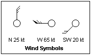 The direction and speed of the wind is represented as shown at the left. The circle represents the station, and is usually filled with a symbol representing the cloud cover. The wind feather points in the direction from which the wind comes. Each long barb represents 10 knots (about 5.15 m/s or 11.5 mph), and each half-barb 5 knots. If there is only a half-barb, it is not drawn at the end of the feather, but a short distance from the end, so it is not mistaken for a full barb. The feather shaft alone signifies a wind of 1-2 knots. Each filled triangle represents 50 kt (75 m/s or 55 mph). Sometimes a solid rectangle represents 100 knots. Note that the direction line points into the wind. A "west wind" blows from the west, as in common usage. Study the upper-atmosphere charts and observe the wind speed decrease at lower altitudes. Also note that the jet stream blows parallel to the contours, with lower heights to the left. This corresponds to blowing along the isobars, with lower pressure to the left. This is called Buys-Ballot's law. In the southern hemisphere, the directions are reversed. If you face the wind, lower pressure is on your right north of the equator, to your left south of the equator. A calm wind is represented by an outer circle concentric with the cloud cover circle; clear skies and no wind is represented by concentric circles.
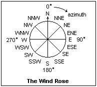 It is often convenient to specify wind direction approximately, and a good way to do this is to use the nautical compass points of the wind rose, shown in the diagram. Although this may be common information, I was unable to find it easily in the usual references, such as my Funk and Wagnalls, or in a desk encyclopedia, so I give it here for reference. These directions are 22.5° apart, which is good enough in most cases. Sailors can split each direction in two, with things like NE by E, but this is excessive for weather work. Accurate directions can be specified by azimuth, such as the azimuth from north shown in the diagram, measured clockwise from 0° to 360°. Surveyor's compass bearings, such as N 34° E, are seldom used for winds. Remember that it is customary to specify the direction from which a wind blows, not the direction in which it is blowing.
The geostrophic wind is an idealization in which the pressure gradient force is balanced by the Coriolis force. The wind speed v is given by the equation 2ω sinφ v = (1/ρ)(dp/dx), where ω is the angular velocity of the earth, 7.292 x 10⁻⁵ rad/s, φ is the latitude, ρ the density of the air, p the pressure, and x the horizontal distance normal to the isobars. The direction of v is along the isobars. This equation is for straight isobars, and must be modified for cyclonic and anticyclonic motion. At the surface, winds are usually low and greatly modified by friction, so they blow at angles to the isobars and often have little geostrophic behavior, except in a strong cyclone. Indeed, at low levels they may blow directly from low pressure to high pressure, perpendicular to the isobars. Upper-level winds are much less affected by friction and cyclonic movement, and so are much more often approximately geostrophic winds blowing along the isobars. This is particularly seen at 250 mb, where jet stream winds follow the isobars very closely, and have speeds given by the geostrophic wind equation to a good accuracy. The lower density at this altitude, less than half that at the surface, means faster winds.
The geostrophic wind equation can be written in convenient units as v = (4.693 x 10⁻³/ρ sinφ)(dp/dn) m/s, where dp/dn is the pressure gradient in mb per degree of latitude (111 km or 69 mi). 1 m/s = 2.237 mph = 3.600 kmph = 1.942 knot. At Denver, where the air weighs 1 kg/m3 and the latitude is 40°, the geostrophic surface wind is 6.95 (dp/dn) m/s.
The jet stream should normally blow along the 50° parallel, separating the polar easterlies, the cold polar air mass and low pressures from the temperate westerlies, warmer air masses and high pressures to the south. What it actually does is twist and snake back and forth between 30° and 60°, bringing the temperate areas the changeable weather that keeps their inhabitants mentally alert. When the jet stream is to the north, the winds are westerly, the weather is warm, and the barometer high. When the jet stream is to the south, the winds are easterly, the weather is cold and the barometer low. This is well-seen here in Colorado at latitude 40°. When the jet stream is north of us, which it is a large part of the time, warm, dry westerly or southwesterly winds blow down the mountain front. Maritime air from the Pacific loses its moisture as it ascends at the wet adiabatic lapse rate (say, 5°/km), then warms at the dry adiabatic rate (10 °/km) as it descends the mountains, becoming the Chinook ("snow-eater") wind that is found where conditions are right from Albuquerque to Calgary along the eastern slope of the Rockies, also known as the föhn near the Alps. When the jet stream is to the south of us, northeasterly winds blow in wetter air that cools and rains or snows as it rises. This "upslope" wind is almost necessary for rain or snow to actually fall in Denver. The only other hope is moist air from the south that has escaped the mountains, and is unstable enough to form thunderstorms. A "low" to the southwest can pump moisture north to meet a cold upslope and give lots of snow, but this is a rare occurrence. Sometimes the jet stream splits, and one current is to the north, near the Canadian border, while the other blows above south Texas.
Winds at 30 to 70 km altitude in the stratosphere in the northern hemisphere are westerly from October through March, and easterly from April through September. The winter winds are from 35 to 140 m/s (79 mph to 315 mph), the summer winds from 5 to 90 m/s (11 mph to 202 mph). During the few weeks of reversal, the winds are light and variable. The greatest winds occur between 50 and 60 km altitude, and have a significant effect on long-distance sound propagation. Not a great deal is known about stratospheric winds and their causes. There is very little transfer between the stratosphere and the troposphere. The stratosphere is convectively extremely stable, and it is difficult for air from below to penetrate into it. Most large cumulonimbus do, however, reach the tropopause and above, where they spread and rain ice crystals into the cloud below, causing precipitation.
Small-scale maps of continental coverage cannot show many local wind features, such as the katabatic winds, which should be distinguished from the chinook or föhn. Famous katabatic winds are the Boulder (Colorado) winds blowing eastward out of the foothills, and the Wasatch winds blowing westward out of the Wasatch. These winds occur when air at higher elevations becomes cooled by radiation and heavier than the air at lower altitudes, and races down canyons as if on a slide. These are cool winds, not cold winds, as they reach the plains after being heated by the descent.
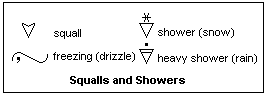 A squall is a strong, gusty wind usually accompanied by rain, snow or sleet. A cold front is often associated with a narrow squall line as it moves forward, usually with thunderstorms that are created in the strong uplift of moist warm air, but thunderstorms are not necessary. Showers are intermittent precipitation from individual clouds; a thundershower is a very typical example. Map symbols for squalls and showers are shown at the left. The kind of shower is shown by a precipitation symbol above. The "lazy S" for freezing is also shown. It is used with one or two "," or "." to show freezing drizzle or freezing rain, moderate or heavy.
A monsoon wind is a seasonal wind blowing from the ocean onto land in summer, normally bringing moisture with it. The wind reverses in the winter, becoming a cold, dry wind. The name is from the Arabic for "season." Monsoon winds are famous in India, where they bring life-giving rains. Monsoons also occur in the U.S. west, with air blowing from the southwest from the Gulf of California and the Pacific, and they bring the moisture to make summer thunderstorms. Monsoon rains are important in Colorado, where they occur typically in July, and the name is now being used quite frequently. They require a strong summer high on the continent to establish the necessary circulation. Monsoon winds are probably driven by a continental high in the winter, and a continental low in the summer, which explains the seasonal reversal in direction. Clockwise circulation around the strong Siberian high in the winter drives winds across China and Tibet into India, while in the summer anticlockwise circulation brings moist winds from the Indian Ocean. The southern hemisphere does not have monsoons, since there are no continents in high mid-latitudes to heat and cool strongly with the seasons, only the constant ocean.
Variations in wind direction at a point are often described as veering or backing. In the northern hemisphere, veering is moving in a clockwise direction, as north to northeast, while backing is moving in the other sense. In the southern hemisphere, conditions are reversed. Sometimes veering is called "moving with the sun" as the sun moves on its diurnal course, which is clockwise in the northern hemisphere and anticlockwise in the southern, since the sun is toward the north there. Confusingly, in "scientific" use the definition for the northern hemisphere is also applied to the southern, an unintelligent convention. Scientifically, it would be better to use clockwise and anticlockwise, not a nautical term. Observe the changes in direction of the winds as the weather moves by a certain location to see how these movements can aid in predicting the weather.
Highs and Lows
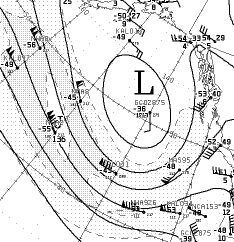
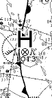
 The next thing to notice on the MSLP chart are the highs and lows, marked by large L's and H's, with their centres marked by circles containing a cross, and their central pressures given. A low in the Gulf of Alaska on 12 June 2003 is shown at the right. This low had broken up by the 15th. These are local highs and lows; the pressure of a low in one part of the chart may be higher than the pressure of a high in another part. The winds will circle anticlockwise around a low, and clockwise around a high. The winds around lows are usually much more intense than those around highs. In some cases, the winds will seem to disregard the isobars, but these will be only light winds. Stronger winds will usually make a small angle with the isobars, toward a low and away from a high. Anyway, do not take my word for it, but find out for yourself. The lows, or cyclones, will be accompanied by considerable cloud (look for black station circles), while the highs, or anticyclones, will generally be associated with clear skies. The main reason for this is that the air in a low is rising and cooling, and rising air usually means cloud. In order to do this, the air must converge on the low. Near a high, the air is sinking and warming, which evaporates moisture and makes clear skies. Therefore, the air is diverging near a high. We are looking at one side of a three-dimensional circulation here, that is not easy to visualize.
Air does not take the short path and simply flow on the surface from a high to a low. The reason is that it moves with so little friction that even small forces have a large effect if they act over a wide area. The pressure gradient is one such force, but another is the Coriolis force. We like to assume that the earth is at rest, but it is actually rotating, so that different places are moving at different speeds. The equator is zipping along, while the North Pole is standing still. If air moves northward, it keeps its original eastward velocity while the surface is moving more and more slowly; it seems to be deflected to the right by an unseen hand, which is the Coriolis force. If we start at the North Pole, no matter which way we head the earth will be moving anticlockwise (eastwardly) beneath us, and again our path will deviate to the right. If, in mid-latitudes, we move directly eastward, the parallel of latitude will curve away to the north, and we will appear to be deflected to the right. The Coriolis force in every case gives the right answer. Quantitatively, the force is proportional to the speed, the angular velocity of the earth, and the sine of the latitude. The wind moves steadily when the net force on it is zero, which means that the pressure force is exactly balanced by the Coriolis force, which requires that the wind velocity follow an isobar. Such a wind is called geostrophic. It is the Coriolis force that makes our atmosphere such a confusing mix of motions. If you add a little surface friction, the wind direction must make a slight angle with the isobar so that the Coriolis force exactly balances the sum of pressure and friction forces.
 A low is shown at the 250 mb surface (about 10 km altitude) at the left. There is also a surface low in this position, which was shown above. This is a major feature extending from the surface to the tropopause, where air is converging and ascending. Note the winds blowing along the southern part of the low: this is the jet stream, with winds up to 120 knots that are blowing directly along the isobars. The anticlockwise circulation continues around the low, but the winds at the north are weaker, only about 25 knots. The jet circulation continues at the northwest, turning eastwards and spreading out. These winds are accurately geostrophic, since the surface has no influence up here. Also note the temperatures at this altitude. There are no fronts at this altitude. The station symbols are based on a black dot; cloud cover is not given, of course, since this is above most clouds.
 If you look at a number of weather maps, winds of higher speed seem to follow the isobars better than weak winds do. In fact, in the vicinity of highs where the isobars are widely spaced, the winds may be perpendicular to the isobars. The Coriolis force is proportional to the velocity, so it will be less important for weak winds. On the other hand, the powerful jet stream winds follow the isobars very well. Lows and highs appear different, in general. Lows are smaller features with tight isobars, while highs are large, even sprawling features with few isobars. They are apparently governed largely by the tendencies of the upper air to sink (in a high) or rise (in a low). Lows are associated with cloudiness and wind, highs with clear skies and calm. Very hot weather produces a "heat" low, very cold weather a "cold" high. These are mainly due to the different effects of the temperature on the correction of the barometer to sea level. They are evident in the U.S. southwest, as shown in the map at the right, and again below. Note the absence of isobars and fronts, and the feeble winds, as well as the high surface temperatures. Lows seem to divide themselves into two classes. Weak lows with central pressures of 1000-1010 mb are surrounded by few isobars, and appear and disappear at random, like the heat low illustrated. Such lows that move along cold fronts are called waves or wave lows, and are not accompanied by much cyclonic circulation. Strong lows with central pressures below 990 mb are persistent and surrounded by concentric isobars, and may deepen into tropical storms and hurricanes. They always are associated with cold and warm fronts.
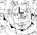 An unusual configuration of a low and its fronts is shown at the left. This low was east of Kamchatka on 12 June 2003. There is a cold front almost parallel to the isobars below it. The broken line probably means that the front is not moving. The front turns into an occluded front to the right. It would be nice if this interpretation of the symbols could be confirmed, or else made correct, by some authority. The cold front turned into a concentric trough the next day.
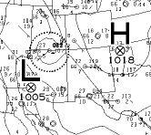 The map at the right, from 15 June 2003, illustrates the effect of temperature on weather map pressures. High 1018 is a general, typical high of the western United States, bringing clear weather and light winds. The temperature at Pueblo is shown as 16°C (this is at midnight local time). A temperature just west of Low 1005 on the CA-AZ boundary is 30°C, and others in the vicinity are also high. As a concrete example, consider my location in Denver, at an altitude of 5360 ft or 1615 m above msl. From my edition of the Handbook of Chemistry and Physics, page E-43, I find that the temperature-altitude index is 163 at 70°F, 178 at 30°F, and 189 at 0°F. The correction of the barometer to sea level at 70°F is then 5.05 inHg or 171 mb, at 30°F 5.56 in Hg or 188 mb, and at 0°F 5.73 inHg or 194 mb. With these tables, it is easier to use English units. Suppose my mercury barometer reads 619 mmHg or 825 mb when the air temperature is 30°C. Then the equivalent pressure at sea level would be 825 + 188 = 1013 mb, the normal atmospheric pressure. However, if the temperature were 70°F, I would report 825 + 171 = 996 mb, definitely a low. On the other hand, if the temperature were 0°F, my report would be 825 + 194 = 1019 mb, certainly a high. It is impossible to say what the sea level pressure actually would be, since there is only rock between me and sea level. However, some sort of correction is necessary to correlate pressures at different altitudes, and this seems to be the best that can be done. At low altitudes, there is little effect of temperature, but up here it can be considerable, and may result in pressures that are not strictly comparable. Another possibility is to use some average temperature and a constant correction, but this may be no better.
In the autumn and winter, the semi-permanent Intermountain High in the U.S. west accompanies the colder temperatures and diverts weather around it, giving the region fine autumn weather and moderate temperatures. The Siberian High is a similar feature. Other persistent cyclones and anticyclones caused by the general global circulation are the Aleutian Low in the north Pacific, the Icelandic Low in the north Atlantic, the Pacific High north of Hawaii, and the Bermuda High in the Atlantic. These are variable, but are usually recognizable on small-scale weather maps. Such maps cannot show certain local circulations, such as the Denver cyclone that forms north and east of Denver in southwesterly winds, an eddy due to topography, or the Colorado Low in the southeastern part of the state, perhaps a temperature effect. Some lows are not persistent, but have been given names because of their typical effects on the weather when they do occur, such as the Texas Low.
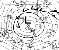
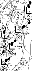
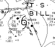 A special kind of low is the tropical depression, tropical storm, or hurricane, which derives its energy from the moisture provided by warm sea surfaces. The second tropical storm of the 2003 season, T.S. Bill, is shown at the left shortly after its appearance on 29 June 2003 in the south central Gulf, and 12 hours later, as shown here, is moving northwards toward Louisiana. The strong winds, 40-50 kt, appeared before the pressure became low enough to be represented as a low, and the cyclonic circulation is evident. Note the tropical storm symbol, which is also used for hurricanes. A day later, on 1 July, Bill had made landfall near Morgan City and turned to the northeast, and was in southern Mississippi, now described as a tropical depression, T.D., with a central low of 1003 mb.
 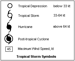 One more day brought it to southeastern Tennessee and a pressure of 1008 mb. It had lost all tropical characteristics, but still provided much rain. As a frontless low, it moved on northeastwards into the Carolinas. Tropical storms in this region appear to be given alternately male and female names, beginning with sequential letters of the alphabet. The third storm, Claudette, appeared around 9 July in the Caribbean, and became a hurricane on the 15th. Hurricanes, among them Claudette, are discussed in the article Wind. Symbols used for tropical storms are shown at the right, together with the maximum winds by which they are classified. Small symbols are used on track predictions, with predicted maximum winds in boxes connected by leaders to the symbol. Hurricanes are also assigned "categories," probably on the basis fo maximum wind speed, but I do not know what they are. Also, a "post-tropical cyclone" is something I have not found defined, but it may be a storm that has migrated to someplace like the North Atlantic.
Fronts
A front is the boundary between two air masses of different temperatures. If the temperature difference disappears, so does the front. The two air masses may differ in water content, and this can have an effect on what
happens. The contact of two air masses is generally the result of motion, but let us assume for the moment that there is little relative motion normal to the front. The two air masses, and the front, can be moved bodily by a general movement, but this does not affect the present argument. Assume that the cold air is to the north, and the warm air is to the south. Since the hot and cold air masses are at the same pressure, the hot air mass is lighter and tends to rise over the cold air, while the denser cold air mass tends to slide under the warm air. The rising warm air may cause air to converge, so the Coriolis force will deflect the cold air under the warm air to the west, and the warm air over the cold air to the east. This is the beginning of a new low, a swirl tending to mix the two air masses that intensifies because of the gravitational energy released in the sinking of heavy air and the rising of light air. Lows predominate along fronts; highs are seldom seen.
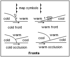 As the low deepens (its central pressure decreases) the winds surrounding it become stronger. To the west, the cold air presses under the warm air, causing it to rise abruptly. To the east, the warm air rides above the cold air, dragging it slowly northwards. These are cold and warm fronts, as shown in diagrammatic cross-section in the figure. The slopes are exaggerated; a cold front is actually 1:50, a warm front 1:100 or so. If the warm air is at all moist, clouds and precipitation result in the zone of lifting. The area south of the cold and warm fronts is called the warm sector. The cold front moves much more rapidly than the warm front, so the warm sector decreases steadily in area. The cold front then overtakes the warm front, at first close to the low, then farther and farther away as it has a greater distance to cover. An occluded front then results, where the warm air is lifted free of the surface. A warm occlusion is the usual result, if the cold air has been warmed during its excursion. Clouds and precipitation persist along this trough. By this time the low is "filling" or increasing in pressure, and soon becomes less and less distinct, having done its job of replacing some cool upper air with some warm surface air. During its lifetime, the low migrates steadily eastward and northward in the general atmospheric circulation. It is a very instructive exercise to follow a low from creation to disappearance on the weather map.
 A persistent deep North Atlantic low from 15 June 2003 at latitude 53° is shown at the left. It is surrounded by 7 closed isobars, which means a depth of around 28 mb. The past history of its central pressure on previous maps is shown as a string of figures curving to the south. 88 means 988 mb, and there are four maps per day. To its southeast is a thin warm sector, the rest of which has wrapped up into an occluded front from east around to north. The jet stream flows around the southern arc of the low at speeds up to 90 or 100 knots, and the low is still evident at the 250 mb level. If this low were further south and over warm water, the input of latent heat would quickly convert it into a tropical storm.
 A front is represented by a thick continuous line. Cold fronts are identified by triangles on the side in which it is moving, or by blue color. Warm fronts are identified by semicircles on the side of advance, or by red color. If the triangles or semicircles are not filled in, it means that the front does not reach the surface. An occluded front has triangles and semicircles on the same side of the line, or purple color. On the Canadian maps, it is also represented by a thick broken line (showing that the front is above the surface) with half-arrow marks in the direction of advance. If a front is represented by alternating red and blue, or if triangles and semicircles are on opposite sides of the line, it is a stationary front, a boundary that has not made up its mind what to do. The situation is unstable, and either the front will disappear as the air masses approach the same temperature (frontolysis), or swirls will occur leading to wave lows. A stationary front that brought much rain to the East Coast in June 2003 is shown at the right. The chain of feeble lows is superfluous, a computer idiosyncrasy. All of these things can be watched in action on the analysis charts.
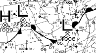 A typical association of lows and fronts is shown at the left. There are two rather weak lows, with central pressures of 1003 and 1006 mb. The front changes from cold to warm, back to cold and then to warm again, in response to the anticlockwise winds around the lows. Since isobars are sparse, winds are light, as can be seen from the station symbols, and are indeed generally anticlockwise. The computer has drawn a high nearly as low as a low just to the west of low 1003, but this high probably has little significance.
 An unusual association of a high and fronts is shown at the right. Note that the clockwise winds make a warm front to the east (above), and a cold front to the west (below). Fronts seldom pass through highs, which are regions of stability and divergence. Many computer-drawn shallow lows are also devoid of fronts. Sometimes the computer gets overenthusiastic in creating them, which crowds out more useful information.
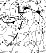 A trough is represented by an interrupted thick line, usually coming from a low where an occluded front would be expected. This occurs, apparently, where the air masses are not well-differentiated, and may succeed an occluded front. It is a line of convergence, and attracts convection, clouds and precipitation. The figure shows a low with warm and cold fronts, and a trough extending southwestward from Omaha to Roswell. Note the cloudiness along the trough. The path of the low for the past several days is marked with central pressures. Sometimes such a trough leads to a low without fronts, but usually comes out of a normal frontal low. A trough is of moderate persistence, and can be followed for several days. The opposite of a trough, a ridge, also exists, but has a less significant effect on the weather. Ridges are generally associated with dry, clear weather, however, since they are lines of divergence.
Map Symbols for Weather and Clouds
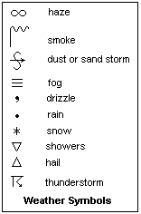 The most often seen weather symbols are shown at the right. The large S for sand or dust has a thicker arrow for a strong dust storm, no arrow if the dust is suspended in the air without a wind, a vertical arrow if the dust is raised by the wind at the time of observation. The haze symbol, looking like infinity, is for a thin dry haze. The fog symbol is for a fog obscuring the sky. Two lines represent a light fog, and if the lines are broken the fog is patchy. The smoke symbol is used when visibility is restricted due to smoke. The drizzle, rain and snow symbols are used in multiple to indicate intensity. One is light, intermittent while four is heavy, continuous. A curved line beneath the symbol means that the precipitation is not reaching the ground (virga).
  The shower symbol is combined with a precipitation symbol to indicate rain or snow shower. The hail symbol may be combined with the thunderstorm symbol, for example, and a dot in the triangle represents sleet. Everywhere except in the U.S., sleet is hail or snow with rain; in the U.S., it is freezing rain with clear crystals (ice pellets). A rain dot or snow asterisk can be used above a thunderstorm symbol to indicate a slight or moderate storm with rain or snow. If the lightning is given an extra zigzag, a heavy thunderstorm is indicated. The sandstorm symbol can be used if the thunderstorm is kicking up dust.
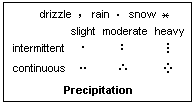 The character of precipitation is indicated as shown at the left. Slight, moderate and heavy intensities are distinguished, as are intermittent or continuous precipitation. Drizzle is rain in tiny drops that cannot easily be visually distinguished, while rain is in visually evident drops. Water is also deposited from colloidal suspension in fogs, but this is reported under fogs. Snow includes any kind of falling ice crystals, except for hail, which is specially distinguished and originates in thunderstorms. The symbol for hail is an equilateral triangle. Frozen raindrops are represented by the hail triangle with a dot in it. Freezing rain and freezing drizzle have their special symbols with the "lazy S." This precipitation falls as water, but freezes on contact with the earth.
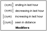 The weather symbols can be modified by the added symbols shown at the right. A right bracket means the weather has ended within the last hour. A vertical line at the right means that the weather has decreased in intensity in the last hour. If the vertical line is placed at the left, in means that the intensity has increased in the last hour. Parentheses mean that the weather indicated has been observed from the station in the last hour, but is not actually at the station at present. For example, a duststorm in parentheses means that a storm has been seen nearby, or at the station, in the past hour, but is not active at present. A thunderstorm in parentheses means that thunder has been heard, but there has been no lightning or precipitation at the station in the past hour. Just the lightning arrow means that lightning has been seen, but no thunder has been heard.
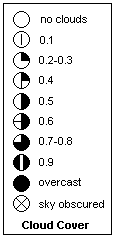 Cloud cover at a station is represented inside the circle from which the wind speed arrow projects. Cloud cover is estimated in tenths of the sky covered from cloudless, 0/10 to overcast, 10/10. "Sky obscured" means that the sky cannot be seen due to smoke, fog or other obstruction. A ceiling is quoted as the height of the cloud base when 6/10 or more of the sky is covered. Visibility is a "hazy" concept; it is the greatest distance at which you can see what you need to see. It can be more precisely defined as the distance at which a specified black shape can be seen against the horizon by day, or the distance at which a 25 cd isotropic source can just be seen by night. Visibility can be measured by some instrument over a fixed range, and this is then extrapolated as necessary. The best practical way is to have a series of targets at known distances, and to note the most distant one that can be distinctly seen. This probably gives better practical results than any objective instrumental method, since it uses actual vision and actual targets. The visibility is often quoted in eighths of a mile. A visibility of more than two or three miles can be called "unlimited," though 10 miles is the usual criterion. The weather scientist is not usually very concerned with cloud cover, ceiling and visibility, but many users are critically concerned with these factors.
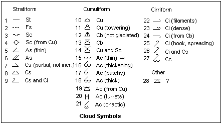 Cloud symbols are shown at the right. Symbols for upper- and middle-level clouds are placed above the cloud-cover circle, and those for lower-level clouds below, so that many station reports contain three cloud levels. Cloud types are often shown for Canadian or Russian weather stations, but do not appear on U.S. reports. Most of these symbols can be seen quite frequently on CWO maps. The symbols are generally divided into stratiform, cumuliform and cirriform clouds, which is usually the best classification. Stratiform clouds do not show convective behavior, and are formed by cooling of moist air. Cumuliform clouds exhibit convective behavior, either the ground-based convection of cumulus clouds, or the upper-level convection of altocumulus, or even the mixing by turbulence at very high levels. Cirriform clouds show the typical features produced by ice crystals. Clouds are composed of colloidal water droplets or ice crystals, and for this reason are white. Middle clouds contain supercooled water, and sometimes ice crystals. Supercooled water in high-level clouds changes into larger ice crystals, which then precipitate, forming the typical cirrus shapes when blown by the winds. Supercooled water can occur at any level, but by -40°C, the change to ice is almost irresistible. Official cloud names are, unfortunately, based simply on appearances, while it would be much better if they reflected atmospheric conditions, such as humidity, instability, turbulence and convection. Names based on altitude are often misleading, since altitude is only one factor that affects cloud formation.
In the figure, St (1) is stratus, usually low and thick, while Fs (2) is fractostratus, or scud, of bad weather, consisting of wind-torn stratus. Sc (3) is stratocumulus, a thick layer of cloud that shows some convective action that can be formed as such. Sc (4) is stratocumulus formed from the spreading and coalescence of cumulus, as often happens in the afternoon. As (5) is altostratus, usually thin perlucidus, covering the sky, through which sun and moon show hazy discs. As (6) is thick altostratus, a high, featureless layer of cloud, or else high Ns, nimbostratus, usually drizzling. Cs (7 and 8) is cirrostratus, an even higher semitransparent layer that is composed of ice crystals, and gives halos. One symbol is for partial cover, the other for general cover. (9) is for a mixture of cirrus and cirrostratus. (7) to (9) are high clouds, ice-crystal clouds showing a tendency to layer formation. Cu (10) is the familiar fair-weather cumulus, made by convection at a low level. If it is cumulus congestus, showing vertical development indicative of active convection, then symbol (11) is used. These clouds may grow into cumulonimbus (raining). If the top has not glaciated, (12) is used, but if an anvil has formed, (13) is correct. (14) is for cumulus with a layer of stratocumulus above it that is not formed by spreading of Cu.
(15) is for a thin layer of altocumulus, Ac, a very common middle cloud often indicative of a coming storm. This symbol, and the ones following, appear above the cloud-cover circle. On small-scale analysis charts, the symbol may appear as at the right in the chart. Symbol (16) indicates that it is thickening, perhaps approaching As, while (17) is used if it is patchy. If the altocumulus is thick, (18) is used, a rather commonly found cloud symbol. (19) is used for altocumulus that has formed by the breaking up of the upper parts of cumulus. One very distinctive altocumulus formation is castellatus, which indicates active mid-level convection. It is indicated by symbol (20). When this has proceeded considerably, altocumulus floccus is formed in which the cloud bases have vanished, for which (15) is appropriate. (21) represents a chaotic altocumulus sky, perhaps indicative of strong wind shear. The distinctive billowing altocumulus, undulatus, does not appear to have a separate symbol, nor does lenticularis, often created orographically.
The usual scattered cirrus filaments are represented by (22), or by (23) if the cirrus has become dense. These are ice clouds, and are shown above the mid-level clouds over the station circle. Dissipated cumulonimbus can leave cirrus from its anvil, which is represented by (24). The hook-shaped cirrus with virgae of precipitating ice, often spreading, is shown by (25). Mixed cirrus and cirrostratus, a not unusual combination, is represented by (26). This is similar to (9), but with not as prominent a stratiform disposition. Finally, Cc (27) is cirrocumulus, a rare high, billowing cloud of supercooled water, often as a wave cloud above mountains, or as a thick, bumpy sheet. I do not know what 28 means yet.
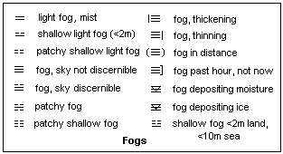 Symbols for fog are shown at the left. They are classified as weather, not cloud, and appear to the left of the station circle (or at the lower right for past weather). For weather map purposes, fog includes all types of aerosols reducing surface visibility, including smoke and haze, though these have their own special symbols, given above. Haze and smoke may be natural or artificial, and are typically a dry aerosols. Haze is also used for a very light fog, with a visibility greater than 1000 m. Smoke comes from fires and volcanoes, dry haze from other sources, such as the salt haze over the ocean from evaporated spray. Both smoke and haze may be dry, but water will nucleate on the particles if the air is humid. Fog is an aerosol of water droplets, usually produced by cooling of the air by radiation or by advection (movment over a cold surface) below its dew point. Ice crystal fogs of ice needles are rare, but do happen, and there may be a special symbol for them. Shallow fog is 2 m or 6 ft in depth, or less, while light fog is that in which there is reasonable visibility. Mist is fog where the visibility is at least 1 km. All the symbols shown have been seen on weather maps, including the modified symbols for changes. When the sky is obscured by smoke or haze, an X appears in the station circle, but in the case of fog it shows the cloud cover above the fog. One can have thick fog, but no cloud cover.
Fogs may deposit moisture or ice when droplets collect on surfaces. This should be distinguished from dew, which is formed directly by condensation from the vapor, and also from drizzle, which definitely precipitates. Both processes may be active, and it is difficult to distinguish between them. Fog-deposited ice is sometimes called rime. Rime ice consists of crystals fused together; it is "white ice" as distinguished from clear "glaze ice." The symbols for fog depositing water or ice are shown in the figure. If the upper line is broken above the V, it means that the sky is visible.
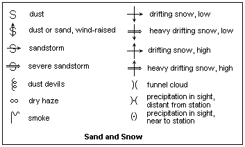 Weather symbols for dust, sand and snow in the atmosphere are shown at the right. Note the distinction between dust suspended in the atmosphere, and dust or sand raised by wind. A duststorm or sandstorm, like the famous Haboob of the Sudan, has a horizontal arrow implying blowing by a steady wind. Slight or moderate storms, and severe storms, are distinguished from each other. Drifting snow is denoted by crossed arrows. The thick horizontal arrow implies blizzard conditions with winds greater than about 30 knots. Low drifting snow is the usual case, with snow not raised above about 5 m. High drifting snow implies snow generally in the atmosphere and very restricted visibility. Dust devils and funnel clouds (usually waterspouts) are vortex phenomena of different strengths. A dry haze restricting visibility is denoted by the infinity symbol (often looking like two o's), while smoke gets a smoking chimney. The smoke is usually from a forest fire or volcano, and must be fairly general to be reported.
The symbols are presented here in an attempt to make them intelligible to us, not to make us experts in speaking the language, since I may not have given accurate definitions, and usage seems to differ a little. Observe the actual symbols that are used on weather maps; most of them can be seen in the space of a few days. I found all the cloud symbols except (25) on the four maps of one day, and symbol (25) a couple of days later in northern Siberia.
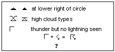 A few symbols I have seen, but have not been able to identify with confidence are shown at the left. The two that look like piles of asphalt pothole fill are more often found at marine and coast stations, but have also been seen inland. They do not seem to be weather, but are found at the lower right of the cloud cover circle near where old weather should be. The cloud type is a combination of stratocumulus, which does not belong at a high level, and an unknown cloud symbol which may have something to do with ice. The gamma-like symbol is very probably as stated in the legend, part of the thunderstorm symbol, since the arrow is for lightning without thunder.
There is a curious tendency among meterologists, who seem not to be Latin experts though many cloud names are Latin to impress the laity, to make a feminine singular in -a into an honorary neuter plural, as in mamma (breast) or virga (broom). The correct plurals are mammae and virgae, which I shall use here though it is not common practice. I have even seen "mammata," getting Greek into the mess, but this horror is not a Greek word! Mamme is a Greek word, but it means mammy, not a breast. Breasts are mastoi. Perhaps it is a back-formation from mammatocumulus, a perfectly correct cloud name.
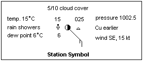 The station symbol includes figures surrounding the cloud circle and wind arrow. The last three figures of the barometric pressure in mb with one decimal are shown in the upper right. The pressure is assumed to be between 950.0 and 1050.9 mb. At one time the analyst had to draw the isobars based on these values, but now it is done by computer. The temperature and dew point are given at the left, with visibility in 1/8 miles (200 m) between them in some cases. A symbol for the current weather is shown at the left, and a symbol for the weather since the last report on the lower right. Figures to the right give the pressure change in 0.1 mb in the last three hours, called the barometric tendency, with a symbol denoting the character of the change. Upper- and middle-level cloud symbols are shown above, and lower-level clouds below the cloud circle. A number to the right of the lower cloud symbol gives the amount of the sky covered by the lower cloud in coded form. [0: no cloud; 1: <0.1; 2: .1; 3: .2-.3; 4: .4-.6; 5: .7-.8; 6: .9; 7: >.9 with openings; 8: 100%; 9: sky obscured] U.S. station symbols are too lazy include clouds, but Russian and Canadian reports do. The office issuing the chart should explain what it includes in the station symbol, but I have not yet found such information. Some web sites with partial information are given in the References, or can be found on the CWO site under Frequently Asked Questions. There is a standard handbook of International Weather Symbols somewhere, but I have not yet found it.
Examples of Actual Station Symbols
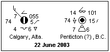 Two more examples of station symbols are shown at the left. They are from Canada, and so they show the cloud symbols. They are from 0600 GMT on 23 June 2003. It is 90% overcast in Calgary, with a 15-knot wind from the northwest. The air temperature is 7°C, and the dew point is 4°C. The barometer stands at 1005.5 mb, adjusted to sea level. It has risen 0.5 mb in the past 3 hours, to become steady. There were showers since the last report, but not at present. The low-level cloud is stratocumulus, while at upper levels there is thin altostratus. Visibility is 74 times 200 m, or about 14.8 km.
Over at Penticton, it is calm and overcast. The temperature is 14°C, and the dew point is 7°C. There are light rain showers at present. Visibility is also 14.8 km. The barometric pressure is 1010.1 mb. The barometer has risen irregularly by 1.5 mb in the past 3 hours. The lower cloud is towering cumulus, with the 6 meaning that the sky is 7/10 or 8/10 covered with it, as in the preceding symbol, while the upper cloud is thick altocumulus.
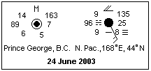 The station symbol for Prince George, B.C. shown at the right indicates that there are altocumulus castellatus covering half of the sky. The wind is calm, the temperature 14°C and the dew point 6°C. The barometer is at 1016.3, and has risen 0.7 mb steadily in the past three hours. Perhaps the 89 is something other than the visibility; if it is, then U. S. stations report a maximum figure of 66, while Canadian stations estimate the actual visibility when it is large. The 5 means that the sky is about half covered with the low cloud.
The station at sea in the North Pacific shows some interesting features. It is overcast, with a 15 knot wind from SSE. High cloud is thick altostratus, low cloud is stratus. The temperature and the dew point are equal at 9°C, so it is no surprise that there is currently patchy fog, while there has been fog since the last report. The barometer is 1013.5 mb, and has fallen 2.5 mb irregularly in the last three hours. A warm front is approaching from the south, and the wind is blowing from high 1026 to the northeast across the isobars toward low 1001 on the warm front (shown on the weather map, not the station symbol!).
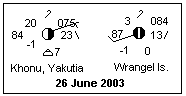 The reports of two Siberian stations reporting increasing cirrus with ice precipitation are shown at the left. Khonu is in deepest Yakutia, on the Arctic Circle where the Indigirka River cuts through the Cherskii Range, east of the Lena. The temperature is a warm 20°C, and in spite of low humidity (dew point -1°C) towering cumulus is forming, in addition to the high cirrus. The other station is on Wrangel Island, 71°N and 180°E, not far from the Bering Straits. There is no low cloud, but the cirrus covers 90% of the sky. This kind of cirrus has virgae of ice crystals falling below it, which are often blown out horizontally by jet stream winds. In this case, however, the jet stream was well to the south of both stations.
Looking at Weather Maps
The CWO Analysis Charts
It may be informative to report my experiences in following the analysis charts supplied online by the Canadian Weather Office. The Complete charts showing actual, not predicted, weather and covering North America are the ones I use, in particular the 90KB smaller-scale maps prepared four times a day, at 00Z, 06Z, 12Z and 18Z. The "Z" stands for Zulu time, UT or GMT. These have to be captured as they appear, since they are not archived online. I print them out at 111 dpi, which makes them come out 203mm x 175mm. I have now discovered that the maps are better printed in landscape orientation, at 100 and 120 dpi. If your maps are a different size, the figures given below will have to be adjusted, but this is easy to do after a little measurement. Generally, I copy the 06Z maps, which corresponds to 11 pm in Denver. My comments here are not those of an experienced interpreter of weather maps, but of someone trying to learn how to use these fascinating tools. The Canadian maps are the only ones I have found so far on the internet that are of professional quality and utility which cover the area in which I am interested, which is the State of Colorado and its vicinity.
The maps are made on the conformal polar projection in which meridians are radial straight lines from the pole, and parallels of latitude are circles. The radius corresponding to latitude φ is R(φ) = C tan[(90° - φ)/2]. This is an excellent choice of projection, and measurements can be made on the map, since it is conformal. May those who perpetrate nonconformal maps be cursed with boils. By measurement, the constant C turns out to be 206mm, at 111 dpi (229mm at 100 dpi). The latitude of any point on the map can be determined by measuring its distance from the pole and using the projection formula. Parallels of latitude are drawn on the map at 10° intervals over ocean areas, divided in 1° subintervals by tick marks. Meridians are drawn at 10° intervals of longitude over ocean area, also divided by tick marks into 1° subintervals. The North Pole is at the upper centre of the map. The Greenwich meridian is inclined upwards to the right at an angle of 20°. The scale of the map is approximately 1 mm = 57.3 km, or 1:57 300 000. The precise scale can be worked out from the projection. A larger scale map is also available if you wish to check local details. It is difficult to read the station data on the smaller-scale map. Hawaii is in the southwest corner of the map, Cuba in the southeast corner, Spain in the northeast corner, and Japan in the northwest. The centre of the map is near Yellowknife, NWT. This is excellent coverage for us in North America.
The isobars are shown at a contour interval of 4 mb. The CWO displays the hectopascal, hPa, rather prominently, but in my only communication with them the good old mb was used. Those who promote hectopascals should be cursed a little, but not with boils. Every sixth isobar is drawn heavy, so there are 24 mb between heavy isobars. The 1000 mb isobar is heavy, as are the 1024 mb and 976 mb. Since pressures are seldom as high as 1048 mb or as low as 952 mb, these are normally the only heavy isobars that appear. At first, I was annoyed that the isobars were not labelled, but now I see that there is little need on the mean sea level chart. With a little practice, one can easily determine the pressure at any point. The station symbols are not easy to read at the smaller scale, but the enlarged version on the website will show them better.
Other heavy lines mark fronts and similar features. Warm and cold fronts are marked with the distinctive semicircles and triangles. If they are not in contact with the ground, the semicircles and triangles are not filled in. Occluded fronts and troughs are marked with broken thick lines. Occluded fronts have half-arrowheads. Lows and highs are marked with large letters L and H, with a cross in a circle at the exact location, and the central pressure nearby. The large L and H are often large enough to obscure important detail, but the computer that puts them there does not care. In April, the computer went crazy and started doubling each L and H, and scattering them thickly over the map.
There are two kinds of highs and lows. One kind has warm and cold fronts trailing out from it. These are almost always lows, with a warm sector that closes slowly. They have a remarkable persistence, often moving from west to east across the whole map, beginning in the Pacific and ending up in England or beyond. These bring cloudiness and frontal precipitation with them. They may deepen, or intensify, or fill, becoming less strong. They are surrounded by concentric isobars, and the winds generally follow the isobars, especially when the isobars are closely spaced and the winds strong. The other kind is not associated with fronts, and maintains an approximately fixed position, surrounded by few isobars and only feeble winds. These are mainly highs, and even the weak winds accompanying them blow clockwise approximately along the isobars, with a significant outward component. The lows of this type are much rarer, and the weak winds generally blow inwards toward the low, generally with an anticlockwise persuasion.
The second type of high or low is associated mainly with slow downwards or upwards motion of air, and occurs when the upper winds are not strong. This indicates that surface events are correlated with, if not controlled by, things that go on higher in the atmosphere. There are upper-air maps on the same site, one published per day, at 850, 700, 500 and 250 mb. These are actually height contour maps of the surfaces at these pressures. If the surface sinks, an area of lower pressure at a constant altitude is created, and if a surface rises, an area of higher pressure is created. Therefore, these maps can be interpreted like the sea-level maps of constant elevation where the pressure is contoured. The 250 mb map is just below the tropopause, where strong westerly winds are common, concentrated in the well-known jet streams. These winds follow the isobars quite accurately, and are very strong, often 90 knots and over.
It seems that south of the jet stream, air is generally sinking and the calm type of high-pressure areas may be seen, with clear air and feeble winds. North of the jet stream, rising air is encouraged, and calm lows may be produced. In this case there are clouds, often at a high level, weak winds, and precipitation if the dew point is sufficiently high. The high cirrostratus often produces halos around moon or sun, giving an indication that the jet stream has moved south and storms are possible. In fact, a band of eastward-moving cyclonic storms is usually present north of the jet stream, so a storm usually arrives before long.
The jet stream often twists around, but normally it moves from north to south by splitting in the middle and making a relatively calm area within it. Then the northern part weakens, while the southern part strengthens, and soon there is only the southern part. A northward move is made in the same way. I always check the 250 mb chart to see what the jet stream is doing when I download the sea level analysis chart.
Surface weather does not seem to move according to the surface winds, but to the winds aloft. The 500 mb and 700 mb charts show the winds in the middle atmosphere, and give an idea where the frontal highs and lows are going. Temperatures are shown on these charts. Areas where the difference between the temperature and the dew point are less than 2°C and 4°C are also shown. This shows moist air prone to cause precipitation. The 500 mb chart also contours the thickness of the 1000 mb to 500 mb layer of air. The thicker it is, the warmer the air is. In the standard atmosphere, 250 mb is at 10 400 m altitude, 500 mb at 5600 m, 700 mb at 3000 m, and 850 mb at 1500 m. The 700 mb winds should be the ones that push around most of the surface weather, and the clouds that you see.
The Denver Storm of 18 March 2003
Now let's follow a cyclonic disturbance from its first appearance in the Pacific until it causes weather in Denver. On 13 March, low 998 appeared at 37°N, 170°W, 6650 km from Denver. It had cold and warm fronts, and made it cloudy in its vicinity. On the 14th, it had strengthened to 986 mb and moved eastwards to 38°N, 147°W, 2290 km in 24 hours, 95 kmph. The cold front now trailed out thousands of kilometers to the west, and the warm sector had begun to wind up into an occluded front. The 15th found it at 42°N, 132°W, having moved northeastwards 1600 km in 24 hours, or 67 kmph, deepening to 959 mb. The occluded front spiraled southward to northern California, the warm front was about to make land, and the cold front trailed far out in the Pacific, nearly to Hawaii. On the 16th, it had filled to 971 mb, and moved northwards to 52°N, 131°W, 1200 km or 50 kmph. There it joined lows 963 and 964 in the same general area of the Bay of Alaska, and the warm sector was now completely wrapped up into a trough that spiraled to the south and west. The cold front now stretched in an arc from northwestern B.C. to southwestern California. The northern part had lifted off the surface, and the southern part had spawned two lows, 999 and 1002. There had been heavy rains in California.
During these days, the jet stream had moved from southern Canada to a path over Arizona and Texas. When Colorado had been between the branches of the jet stream, a high had persisted until the 10th, when its pressure was 1021 mb, skies were clear, and the weather in Denver was warm, approaching the 70's. On the 11th, a weak low at 1009 mb appeared over northeastern New Mexico, but the fine weather did not change. On the 12th, it had been joined by low 1008 over Yuma, Arizona and low 1004 over Sheridan, Wyoming, while it deepened to 1006 mb. On the 13th, a high of 1020 mb reappeared over Grand Junction, Colorado, and was still there on the 15th at 1013 mb, but joined by lows 1002 and 1000 in Nebraska and South Dakota, as the cyclone hit California. By the 17th, there were no fronts at all over the United States, and two lows that had appeared near Cheyenne, Wyoming at 994 mb and near Raton, New Mexico at 993 mb coalesced to a single large low over Hugo, Colorado at 991 mb. Surface winds blew into this low from all directions, but only at 10 kt or so. On the night of 16-17 March in Denver, clear skies were replaced by a thin, uniform layer of cirrostratus that caused a halo around the moon, which could be seen through the cloud. Later, the cirrostratus was replaced by broken altocumulus.
It is of interest now to tell what the weather reports were on the 16th. The Weather Bureau said that rain would begin overnight, with probable thundershowers by the afternoon of the 17th, changing to snow later. On the 18th, there would be from 4" to 8" of snow in Denver, blowing and drifting, while the temperature would be in the 20's. The Denver Post said "Blizzard bruiser is aimed at state" on the morning of the 17th. The storm could be as bad as the October 1997 blizzard that left nearly two feet of snow, it was claimed. There was some moisture on the morning of the 17th that could have been either light rain or dew, and it drizzled now and then during the day. It was dull, but there was a sunny interval in mid-afternoon. Later, there was light rain and the temperature was 45°F. There was practically no wind--Force 0 or Force 1 at the most. The humidity of the air increased about 24 hours ago, showing that moist air had arrived as the lows formed. This was an increase from about 10% to about 30% indoors. In some limited areas, hail was reported, and a tornado watch was proclaimed. Also, the rain increased to moderate here, before ceasing by nightfall. Apparently, there was some convective activity, but none could be seen because of the thick stratus cover.
A check of the weather maps showed that there was a large area of high dew points to the west and southwest of Denver. This was the maritime polar air that came in behind the cold front, and then rode up over and mixed with the air in the western United States. There was also a tongue of cool air, 30°-40°F, reaching down from Canada across the Great Basin, representing this cool, but not cold, air. There was no freezing air except in very small areas at high elevations. The winds at 500 mb and 700 mb were strong from the southwest and south. The nature of the storm now changed.
The weather map for 18Z on the 17th showed that fronts had developed attached to the main low in southeastern Colorado, which had deepened to 990 mb from 991 mb as it moved slowly southwards. A warm front extended north, while the cold front spiraled around New Mexico, preceded by a second front from a low in souathwestern Texas. A southerly flow of air to the west had replaced westerly winds, and the winds just to the west of the warm front had become northerly, though those to the south still flowed radially into the low. To the east, a northerly flow from the Gulf developed. Now there was a new situation, with easterly winds behind the warm front in Colorado about to blow upslope. These winds were quite warm, but rode up on north winds at about 3° or so. The air was moist, with cloudiness beginning in Kansas and extending from there to the Gulf, behind clear air. At about 10.30 pm, rain began in Denver as the temperature struggled downwards to near freezing. Light winds, about Force 2, veered to the east as the upslope developed, and by 11.30 a light snow began that coated the grass but melted on the streets.
At 06Z on the 18th (which was 11 pm on the 17th in Denver) the low had continued its slow southern motion to the New Mexico border and deepened to 987 mb. The warm front had not changed in position (the cold air was packed against the mountain front, while the warm air continued to ride over), but the cold front had spiraled east over Kansas, Oklahoma and Texas. Air flow around the large low curved around from the upper prairies through Nevada and Arizona, and then down the west coast of Mexico. In Texas, the low at 994 mb at the end of the cold front from our low 987 was in the middle of something labelled a "dry line." A search on the Encyclopedia of the Atmospheric Environment and in technical dictionaries did not reveal the meaning of this term. The fact that it was labelled suggests that it was not something common. It was represented by a line of squares or diamonds.
Overnight, the light snow changed to heavy snow, and about 6"-8" of heavy, wet snow fell overnight on Denver. There was only light wind, and the temperature was close to 0°C. Apparently, there was more snow to the west, up to the Continental Divide, but not beyond, and rain just to the east of Denver, which persisted through the day. This is an excellent example of an upslope turning what would be expected to be rain into a snowfall. The moist air rode above the cold air below, cooling and precipitating through air cooled by rising at the mountain front. The weather map for 18Z, shows the low filling a little to 989, and now over Clovis, New Mexico. The cold and warm fronts intersect to the north, near Goodland, Kansas, as they had done for 12 hours. The warm front is actually moving eastward, in reverse, but easterly winds maintain the upslope condition. The cold front now spirals boldly through Oklahoma and Texas into Mexico, which should soon cut off the flow of Gulf maritime air, and so the snow.
Upper-air charts all showed a pronounced low over the surface low. 850 mb was at 1260 m, 700 mb at 2820 m, 500 mb at 5390 m, and 250 mb at about 10,220 m. The 250 mb low was a bit farther west, but this storm extended from the surface to the tropopause. It is clear that the winds were not carrying the low along, but that the low was generating the winds, and it was an eddy in the troposphere in the centre of which air was ascending. The jet stream curved around the southern reaches of the depression, through northern Mexico, and then into Texas and eastwards, at speeds of 90 to 100 knots. This storm was correctly predicted by the Weather Bureau before any changes in the analysis charts showed the creation of fronts and the impending upslope, which is very creditable. They must never predict less weather than actually arrives, so their slight exaggeration may be excused. Television reports did not make clear how snow would be restricted to a belt in the foothills until later, though this was eventually admitted. This storm was very instructive in its effect on Denver weather, and how moisture arrives here. While the usual westerlies prevail, a storm from the Pacific causes little dampness in Denver, and the Chinook is dry as a bone. Moisture in Denver requires an upslope wind, and moisture from somewhere, either from the southeast Gulf of Mexico) or the southwest (Gulf of California), which usually means a low to the southeast.
By the morning of the 19th, the snow had ended, and the low was slowly receding to the southeast. The storm left about 31 inches (79 cm) of snow, and because the winds were light, it was little drifted. The water content was stated at 2.8 in (71 mm) of rain. Temperatures then rose into the 40's with sunshine, and the snow was largely melted by the 24th. There was never a hard freeze, so ice was no problem. Although the deciduous trees did not yet have leaves, the heavy snow still did considerable damage in the conifers, breaking limbs and pulling down power lines. Even city customers were without power for up to three days in some areas. As is typical in the U.S., residential feeders are cheaply hung on poles, and so are very susceptible to damage, besides being unsightly. In Denver, main streets and the Mayor's residential street were soon cleared, but people mainly had to clear their own streets, and did not manage to dig out until the 21st or 22nd.
Some Station Symbols from June 2003
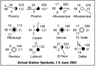 A dozen station symbols from CWO charts for early June, 2003 are displayed at the right. At the left we always have the temperature and the dew point. Between them is a figure that may be the visibility in 1/8 miles, or the metric equivalent, 200 m. This figure quite commonly is 66 in U.S. reports in fair weather, but never seems to sink to small values. At times it is larger elsewhere, in the 70's and even 90's, and it would be nice to know exactly what this figure represents. Note how the dew point approaches the air temperature when there is rain; also, thunderstorms are more frequent when the dew point is high. One can look at the lightning maps on the CWO, which often show where thunderstorm activity is high. A few of the symbols show precipitation, the three dots for heavy rain, and the two dots for moderate rain. When placed to the left of the symbol, it means the rain is current; to the lower right, the rain happened since the last report.
At the upper right is the barometric pressure. At Phoenix, the pressure is 1003.3 and 1005.0; Casper shows 1019.8. A figure of 825 would mean a pressure of 982.5 mb. Such pressures below 1000 mb are found only near deep lows. The number to the right gives the change in the pressure in the past three hours, with a symbol indicating whether it is rising, falling, or behaving in a more complex manner. Weather symbols below here would mean past weather, and occasionally occur. The meanings of the cloud cover circle and the wind feather are clear. Note that an outer circle means calm, of which several examples are given. All winds shown are light, which was a feature of the weather these days over most of the country. These are U.S. stations, and regrettably do not show cloud types.
Phoenix shows hot, dry air, which was typical in the southwest on these dates. It is noticeable that this is associated with low pressure, probably due simply to the correction of the barometer to sea level. The surface temperature is used to calculate the weight of the air column, and it will be lighter when the air is hot. In the winter, the correction works in the other direction, and a permanent high appears over the cold plateaus of the west. This is discussed in more detail above.
The computer that draws the CWO maps often displays numerous shallow lows that are not associated with fronts, and are almost never associated with closed isobars around them. This June they frequently appeared south of the jet stream, unlike their behavior in the winter. In the first week of June in Denver, some cold air began moving rapidly south from northern Alberta. These phenomena are called "Alberta Clippers" from their rapid motion, and usually occur in winter, bringing very cold weather and snow. The Casper symbol shows what this air was like when it reached there, not much more than a day after it was still in Alberta. The front brought rain to Denver on the 6th. By this time, it was clearly marked as a cold front sweeping south and east, while warm air from the southwest pressed its western boundary, and a warm front appeared on the map which had not been there when the air was moving south. No low ever separated the warm and cold segments on the weather map. By the 8th, a reasonable high (1019 mb) covered the center of the west, replacing the southwestern lows. This high was probably due to the fall in temperature. It is interesting to try to understand these movements in spite of their chaotic behavior. By all means, look at some maps for yourself!
From Equinox to Solstice
A benefit of collecting a series of weather maps is the chance to observe the changes in weather patterns with the seasons. Although the chaotic swirls of the atmosphere are continually evident, and defy brief description, there are definite trends and characteristics of a periodic nature that repeat with the seasons. One thing missing on weather maps that would be very illuminating would be some representation of the temperature and humidity of air masses, perhaps by a light patterned tint. In the absence of this, one must go by station reports and the representation of fronts. This section gives some comments on weather from the end of March to the end of June, 2003, for North America, which did not seem different from the ordinary.
At the end of March, the jet stream meandered from just above 20°N to 65°N, with a strong northern band looping around high-level lows, and a weaker, straighter southern band with lower wind speeds. On the average, it blew at about 40°N, across the United States, with peak winds of 100-150 knots. Deep lows formed between Greenland and Iceland, with central pressures of perhaps 965 mb. These lows moved off to the east, circling the pole over northern Russia until halted by Siberian highs. There was a persistent high between Hawaii and California, as well as polar highs over northern Canada. A strong low occupied the Gulf of Alaska, representing the persistent Aleutian Low. There was often high pressure over the Bering Sea. Lows spawned in the North Pacific ran rapidly eastward between the highs to the west coast of North America. There was a tendency for these lows to turn northward into the Gulf of Alaska, especially with blocking high pressure over California. When this blocking was ineffective, the cyclones moved southeastwards between the highs and passed overland, as a low-pressure area with warm and cold fronts. These fronts moved on into the Atlantic, perhaps strengthened near Greenland, and travelled over northern Scandinavia.
High pressure would then form in the western United States, then break down under the assault of further Pacific lows coming from the northwest. At the beginning of April, there was a strong, extensive high at about 45°N, south of the Aleutians, with central pressure 1045 mb, and a smaller high north of Alaska, with central pressures 1037 and 1033 mb. A low of 1002 mb was between them off British Columbia, pressing cold fronts before it into the Pacific states. This low intensified on 2 April as it became a complex system of lows and fronts moving eastwards. By 5 April it was over Ohio, on the 6th over the Maritime Provinces, and by the 7th had cleared land into the Atlantic. It was followed by a train of lows, until they were blocked by high pressure, which was general over the western U.S. on the 8th. Lows were diverted northwards into the Gulf of Alaska, or into northern Canada as high pressure persisted over the west. The first heat low of the season appeared in the area around Yuma, Arizona.
By mid-April, both tracks of the jet stream had moved northwards, the upper one to 50°N and beyond, the southern to about 30° and weakening. High-level lows developed between the tracks, which was reflected in surface lows that again allowed access to Pacific lows from the northwest, which again travelled across the continent in about a week. By the 26th, the jet stream had again moved south to around 40°N, but high pressure was building in the Gulf of Alaska. By the 29th, weak lows in the west were moving rather slowly eastwards, sometimes making no progress in the course of a day, and appearing and disappearing here and there. The southern track of the jet stream was also rapidly disappearing, leaving only the northern track, generally at about 50°N, except over the U.S., where it meandered from 35°N to 45°N.
At the end of the first week of May, high pressure (1037 mb) dominated the Gulf of Alaska, effectively blocking Pacific lows and diverting them to the north. Within a southern-going meander of the jet stream, the western part of the continent was covered by lows that slowly moved eastward. A low with fronts over southeastern Colorado on the 8th had moved to Omaha on the 9th, to Wisconsin on the 11th, over Lake Huron on the 12th, near Montreal on the 13th, near Halifax on the 14th, and over Newfoundland on the 15th. This low was moving at roughly half the speed of the equinoctial lows. The jet stream had split again, one track over northern Canada at about 60°N, the other across the U.S. at 35°N. The high in the Gulf of Alaska remained strong, and continental lows seemed to be climbing it northward, rather than moving eastwards. There was a strong low over northern Saskatchewan of this type.
By 20 May, high pressure had invaded the region off the west coast, and a strong low south of the Aleutians was pressing it. This low stalled in the Gulf of Alaska, the high pressure first seeming to give way a little, then strengthening to a general high pressure region (1021 - 1026 mb) over the western U.S., extending into Qué:bec and the Prairie Provinces. On the 24, conditions were much the same, the low taking up residence in the Gulf of Alaska at 978 mb, attacking the declining high pressure with a weak cold front pressing into the northwest. By the 26th, there was a line of wave lows along a front extending from the Pacific southwest of California, through Idaho and Montana to a low in the Yukon. This front crept eastwards very slowly, and by the time it reached Colorado on the 28th, it had disappeared as the distinction between its air masses vanished due to ground contact. High pressure was again building, but the stationary low in the Gulf of Alaska continued to throw off fronts at 986 mb. These fronts did not make it to land, but new wave lows formed east of the Pacific high pressure along the coast.
On 3 June, an extraordinary line of wave lows extended from Mexico, through west Texas, northwards through eastern Colorado and western North Dakota, then bending a little westwards across Saskatchewan, through the Yukon, and ending finally in a low north of Alaska. The whole line extended from at least 25°N to 75°N, and was marked more by a trough than a front. There were heat lows to its southwest. On the 6th, it was still represented by a trough that had moved eastward a little, to eastern Oklahoma and western Minnesota. The southernmost low, a heat low over north-central Mexico, was still there.
The high in the Gulf of Alaska, 1030 mb, had reasserted itself by 8 June, and was blocking a Pacific low, 993 mb, to the west, while propelling a weak low, 1005 mb, with fronts, southwards over the northwest U.S. The western U.S. was dominated by a high (1019 mb), with the heat low (1001 mb) over southern Nevada. There were weak cyclonic systems over the eastern U.S., bringing clouds, fog, and rain. The jet stream was unified again at about 50°N, but with a deep southern meander as far south as Arkansas. The descending part of the meander was over the high pressure and clear skies in the west, while the ascending part followed the wet weather of the east. There was another long trough curving westwards from the heat low in Mexico through Nevada and Idaho into British Columbia, with its wave lows. The appearance, disappearance and slow motion of these disorganized low-pressure areas was typical of the month, very different from equinoctial weather moving quickly from the west.
On the 12th, a rather impressive low (988 mb) had formed in the Gulf of Alaska, surrounded by 7 isobars and swirling a long cold fron to the south and west. On the 13th, it was still there, having deepened to 980 mb, but the cold front had vanished, and only a short trough to the south was evident. On the 14th, the fronts were back, now with a warm sector and a short occluded front. High pressure still dominated the continent and the Pacific. On the 15th, all was gone, while the Pacific high had intensified. The jet stream had moved generally northward of 50°N. The Pacific high probably represents strong downflow of warm air south of the jet stream that rapidly filled the low. When the jet stream is farther south, the upward currents probably intensify the low in the Gulf of Alaska.
On the 18th, a long trough extends from northwestern Mexico through Nevada and eastern Oregon to lows near the southern border of the Yukon, while high pressure dominates the continent. A front coming in from the Pacific turns into a stationary front just to the west of the trough on the 19th, while the trough itself has moved into eastern Nevada, Idaho, and Alberta, ending in a low at about 60°N. Shortly afterwards, the stationary front and the trough had merged, and a wave low had formed along it. The midwest is beset by fronts, troughs and weak lows. On the 20th, the midwestern fronts and lows have moved to the east coast, where they produced an unusually continous rainfall. To their west is a good high (1022 mb), while the northwest is a chaotic mess of lows and troughs, hardly moving at all. Things are a little more organized on the 21st, with a reasonable cyclone over eastern Montana (994 mb), with a trough to the southwest and a cold front to the south. This low, and companion lows, move directly northwards into the Prairie Provinces, blocked by the high centered over Ohio. The jet stream is now well to the north, as far as 60°N, but there is a large meander southwards as far south as Nevada. The jet winds are considerably lighter than as the equinox, rarely reaching 100 kt. We have now reached summer conditions, when fronts hardly move and disappear quickly. The winds across the U.S. west seem to come from the southeast, driven by the midwestern high and carrying moist tropical maritime air, which explains the more normal rainfall in eastern Colorado this year. I would suppose that if a persistent high does not form in the midwest, then drought comes to Colorado, but this is mere speculation.
I plan to study the Colorado monsoon this August in the same way, which should result in some interesting conclusions.
References
Weather internet links where synoptic charts can be found: Canadian Weather Office; Met Office; Australia; New Zealand; NOAA; Michigan. The University of Central Michigan site has many links, including webcams. Many of the commercial external links are cookiepushers with intrusive, vulgar, crass advertising, so beware. The surface weather map from Intellicast is much better than the poor, muddy map from The Weather Channel. Both are much inferior to the Canadian analysis charts, and not intended for serious use. The weather map illustrations in this article are from the CWO.
The Encyclopedia of the Atmospheric Environment is an excellent source of atmospheric and weather information. Since it is not an American site, it contains useful information for all without nasty surprises. Articles for children are marked with Bart Simpson, while regular information is marked with Mr Montgomery Burns.
U. S. Department of Commerce, Civil Aeronautics Administration, Pilots' Weather Handbook, CAA Technical Manual No. 104 (Washington, DC: Dept. of Commerce, 1955). There are surely later editions of this excellent handbook, which contains a lot on weather maps.
E. W. Hewson and R. W. Longley, Meteorology Theoretical and Applied (New York: John Wiley & Sons, 1944). An excellent general textbook of meteorology. A more recent text would be desirable, but there are not many of equivalent quality and readability.
F. A. Berry, E. Bollay and N. R. Beers, editors, Handbook of Meteorology (New York: McGraw-Hill, 1945). Contains a great deal of information, including weather symbols and cloud pictures. There have been changes since the date of this work, but most of the information is still useful.
V. J. Schaefer and J. A. Day, Peterson Field Guides: Atmosphere (Boston: Houghton Mifflin, 1981)
D. M. Ludlum, The Audubon Society Field Guide to North American Weather (New York: A. A. Knopf, 1991). This and the preceding work are excellent guides to clouds and the weather, though nontechnical.
For the reduction of the barometer to sea level, see pp. E-42 and E-43 of The Handbook of Physics and Chemistry, 56th ed. (Cleveland: Chemical Rubber Co., 1975), or another edition.
One site for symbols is IGES and another is AMS. The first is mainly weather symbols, the second does not give full information on station symbols. Neither shows all the variations in fronts and troughs. A third source is More Symbols.
Return to Weather Index
Composed by J. B. Calvert
Created 2 March 2003
Last revised 11 January 2005