|
Contents –– name –– About the Transcription –– Bibliographic Information |
The Plough Boy JournalsThe Journals and Associated Documents The Plough Boy AnthologyDictionaries & Glossaries |
THE SCOTTISHGEOGRAPHICALMAGAZINE |
who brought Kanaka wives with them. These and their descendants, to the number of about seventy, formed the sole population till the advent of the Japanese, who now number nearly 6000, and have founded a regular government, introducing schools, posts, roads, and other elements of a civilised community. The sugar industry has been largely developed, and sugar is now the chief article of export; some trade is also done in canning turtle and pine-apple for the Tokyo market. The half-caste settlers, who all speak English, remain on, as Japanese subjects, in their old holdings, and continue to live in cabins, thatched with the leaves of the cabbage palm. Many of these men spend the summer months sealing in the North Pacific. Most of the children now 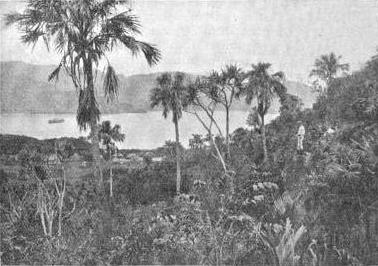
Port Lloyd (Chichi-jima).attend the Japanese Government Schools. These English-speaking settlers are Christians, and one of their number has been licensed by the Bishop of South Tokyo to act as their catechist and to carry on missionary work among the Japanese.1 The vegetation is tropical and luxuriant, including pine-apples, bananas, lemons, and oranges. No snakes or other venomous reptiles exist, and but few birds or butterflies;2 but cockroaches and ants are everywhere a plague. A species of bat is found measuring some three 1 Further details about the history of the Bonin Islands and the early settlers there may be found in Captain Beechey's Narrative, vol. ii. chap, xviii., in Commodore Perry's Narrative, vol. i. chap, x., and in vol. iv. of the Japan Asiatic Society's Transactions, 1876 ("A Visit to the Bonin Islands," by Mr. Russell Robertson). 2 Seebohm, in an article on the birds of the Bonins, says that after the winter visitors have been eliminated there remain only fifteen residents; and after further eliminating ocean birds with ranges of considerable extent and Japanese birds, he found but eight species peculiar to the Bonins. |
feet from wing to wing. The sea swarms with sharks, and the coast is visited by large turtles, which are caught by men from canoes. Passing Parry's Group – a number of fantastically jagged rocks – and leaving Ototo and Ani-jima on the left, the steamer enters the beautiful circular harbour of Chichi-jima, formerly known as Port Lloyd, apparently the crater of an ancient volcano. Of the numerous abrupt hills, all thickly wooded, that rise on every side, the highest is Asahi-yama (880 feet), at the east or upper end of the harbour. Behind a stretch of yellow sand on the NW. side stands the village of Omura, the seat of the local government. Most of the foreign settlers live at Okumura, a little to the NE. On the opposite or S. side is Ogi-ura, the only other fair-sized village. Haha-jima, which lies 35 miles to the south of Chichi-jima, is some 7 miles long by 1 1/2 miles broad. It has no harbours. The steamer anchors some two miles off the village of Okimura, which lies in a shallow bight with a picturesque approach. Though the island is hilly (highest point 1470 feet) and rockbound, its numerous valleys, well adapted for sugar cultivation, make it the most flourishing of the whole archipelago. A large breed of cattle find good grazing ground in the southern part. These animals furnish a rough amusement to the inhabitants by a peculiar kind of bull-fight in which men take no active part. The beasts are led into an arena. until their heads come close together, and the ensuing contest is one of brute strength. Victory is declared, as in ordinary Japanese wrestling, by the weaker being pushed outside the ring, or a throw may sometimes even occur by the two pairs of horns becoming interlocked. Little injury is allowed to be inflicted. The highest temperature during the three years (1897-1900) did not exceed 95° F., whilst the lowest registered was 48° F. The population of the twelve islands included under the denomination of the Ogasawara Islands is: Japanese, 5450, of whom 3086 are men and 2364 women; foreign settlers, 100, of whom 43 are men and 57 women. Professor Yoshiwara, with whom I made the tour, and who was specially sent by the Imperial University of Tokyo to investigate the geology of the islands, has kindly furnished me with the following interesting note. He says: "All the islets of the Ogasawara Group show the same geological formation. The chief rock in the Chichi-jima sub-group is agglomerate tuff alternating with andesite lava. . . . These two sub-groups (Chichi-jima and Haha-jima) are typical submarine volcanoes, sending out numerous streams of lava by subsequent eruptions after frequent periods of repose. Thus the submarine volcanic eruption of the Ogasawara Group began in the Eocene epoch, and had already ceased before the Miocene. This old volcanic chain must therefore be separated from the Fuji chain, which is younger Neogene, or partly even still more recent in origin. No indisputably Eocene volcanoes corresponding to the age of this chain have yet been found in Japan." |
TRANSCRIPTION NOTESSome tables have been reformatted for clarity in HTML presentation. |
authorname, dates |
BIBLIOGRAPHIC DESCRIPTION
|