| |
Abstract and Notes
|
|
Ground-Penetrating
Radar (GPR) Mapping as a method for planning excavation strategies,
Petra, Jordan
The Importance of Using
GPR in Archaeology
 The Importance of GPR For Reconnaissance mapping The Importance of GPR For Reconnaissance mapping
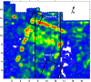
- GPR can produce amplitude-slice maps of large grids of data very
quickly, and these can be used to plan excavations, or define areas
for more detailed surveys.
- If the velocity of radar energy in the ground is calculated, a
series of slices can produce a three-dimensional picture of a site
in true depth.
Figure
18
Figure
19
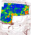
Figure
20

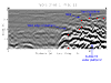
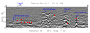
- Analysis of individual reflection profiles within grids give a
more detailed two-dimensional picture. Excavations can then
be placed directly on features visible in profile.
Figure
34
- Video images that show changes in amplitude with depth are particularly
helpful in finding some features, which may not be immediately visible
in profiles or amplitude slice-maps of larger sections of the ground.
Figure
23
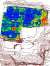
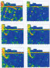
High Resolution GPR Maps Over Areas of Importance
- Once maps are made of a site, and areas of importance are delineated,
it is important to re-collect high definition data in smaller grids.
Figure
40
- High definition data can not only produce images of buried architecture
with more accuracy, but the individual profiles reveal subtle stratigraphy
that can also be important.
Figure
25
Data Re-Processing and Visual Image Production
for Overall Site Evaluation
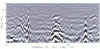
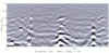
- Data should always be processed to remove background noise and
high angle tails of reflections hyperbolas to produce more accurate
reflection profiles of buried features.
Figure
29
Figure
30
- When processed reflection profiles are used to produce amplitude
time-slices, the resulting three-dimensional maps are a much more
accurate representation of the subsurface.
Figure31
GPR as a Tool for Prediction and Correlation
- Our work at Petra shows how GPR mapping can quickly and accurately
make maps of large areas of a site. In addition, subsequent
excavations are always necessary to confirm GPR results.
- The correlation of GPR reflections to excavated subsurface features
is necessary in order to project information into un-excavated portions
of a site.
Future Possibilities for GPR Mapping and Integration
into Standard Archaeological Excavation Strategies
- In the future we envision using GPR mapping for:
- Initial site reconnaissance
- A guide for placement of excavations in the most promising,
or important areas
- The production of high resolution images of features that
may never be excavated
- Creating three-dimensional rendered images and maps of large
buried sites, with a minimal amount of excavation
- As with any scientific endeavor, our GPR work at Petra has allowed
us to ask even more questions than were considered in the initial
research plan:
- For the future we are planning additional excavations to test
many other features that have been mapped by GPR.
- A number of other potentially important structures have been
found in the "Lower Market," whose age and function
can only be postulated without further excavations.
- Buried soil horizons from what appear to be ancient gardens
have been found and mapped spatially. Smaller features
associated with those gardens must now be excavated to better
understand the function of this site over time.
- Additional GPR surveys will be conducted using higher resolution
antennas, to produce even more detailed images of the subsurface.
|
|


