| |
Abstract and Notes
|
|
Ground-Penetrating
Radar (GPR) Mapping as a method for planning excavation strategies,
Petra, Jordan
Introduction: Finding and Mapping Deeply
Buried Archaeological Features

Archaeologists have long puzzled over strategies
for locating and mapping buriedarchaeological features. Often field
researchers have relied on coring, auguring, and shovel testing, which
are random search methods at best. Geophysical methods such as magnetometers,
resistivity and electro-magnetic conductivity can produce maps of buried
features, but ground-penetrating radar (GPR) is the only technique that
can make maps in three-dimensions.
Ground-penetrating radar (GPR) is a three-dimensional mapping technique.
-
GPR creates pulses of radar energy at a surface antenna
and projects them into the ground. As the transmitted
radar waves encounter chemical or physical changes in the ground,
energy is reflected back to the surface and recorded at the antenna.
-
When the antennas are pulled across the ground in transects,
a series of subsurface reflections are recorded.
Figure
1
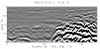
- All reflections are then plotted in a two-dimensional profile.
When radar travel times are converted to depth, the GPR images can reveal
some of the buried features and stratigraphic layers that are usually
exposed during excavation.
Figure
2
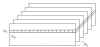
- Three-dimensional GPR data are obtained by collecting many transects
within a grid. When transects are spaced closely together and
the reflections from all the transects are analyzed spatially, they
produce a three-dimensional "cube" of the data.
Figure
3
Since GPR maps can be produced immediately after data acquisition, they
can be used to plan excavations without delay.
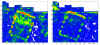
- Maps are typically produced in horizontal slices showing the presence
of buried archaeological features across a site. They are similar
to arbitrary level-maps in standard archaeological investigations, except
they are showing the strength of radar reflections within certain depth
intervals.
Figure
4
- Subsurface testing can be planned from the GPR slice maps, allowing
for a non-random testing strategy where the location and depth of most
of the buried features is known in advance.
- During and after test excavations GPR maps and profiles can be calibrated
by correlating the GPR reflections to excavation data.
- When limited excavation information is used to further interpret the
GPR maps, the un-excavated portions of the site can be characterized.
Petra
was used as a test site for the integration of GPR and excavation data.
Figure
5
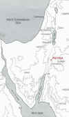
-
A flat area 88 x 51 meters was surveyed, called the
"Lower Market", where little was known about the subsurface,
and there were no surface indications of buried features.
Figure
6
|
|


