| |
Abstract and Notes
|
|
Ground-Penetrating
Radar (GPR) Mapping as a method for planning excavation strategies,
Petra, Jordan
The "Lower Market" Site at
Petra
 The
"Lower Market" at Petra, Jordan The
"Lower Market" at Petra, Jordan
- In the vicinity of the study area are abundant remains dating from
the Nabataean through Byzantine periods.
- The "Lower Market" is adjacent to the "Great Temple,"
overlooking the colonnaded street. It was chosen for archaeological
investigation because of the presumed economic and political activities
that may have taken place there.
Figure
7

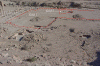
- The ground surface of the "Lower Market" is relatively flat,
with few surface artifacts or architecture.
Figure
8

Previous
Excavations at the "Lower Market"
- Excavations beginning in 1998 indicated the "Lower Market"
may be the location of a formal garden with a pool.
Figure
9
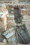
- These excavations showed that most architectural remains were buried
1-2 meters below the surface.
- It was soon realized that the untested area in the "Lower Market"
was much too large to evaluate with traditional excavation methods,
so geophysics would be necessary.
The
Plan for Using GPR
- GPR was chosen because it works well in dry sandy soils, and because
it can produce three-dimensional images of the subsurface.
- It was decided to first cover most of the site with a coarse grid
in order to map the location of most of the larger features.
- Once the "big picture" was understood, data were collected
in a finer grid to focus on certain areas of interest with greater resolution.
Figure
10
- When three-dimensional maps of the buried features were created, test
excavations were placed in areas that would produce the greatest amount
of information in the least amount of time.
|
|


